Karacaköy geodata
Karacaköy (Istanbul) is a seat of a third-order administrative division; located in Turkey in Europe/Istanbul (GMT+3) time zone. In our database, there are 1323 cities with bigger population. Compared to other cities in Turkey, 93.1% of cities are located further ↓South; 77.3% of cities are located further →East and 82% of cities have higher elevation than Karacaköy. Note1


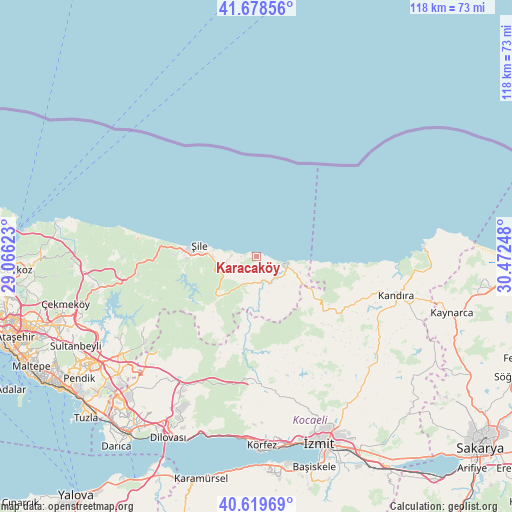
Karacaköy GPS coordinates[2]
41° 9' 4.536" North, 29° 46' 9.66" East
| Map corner | latitude | longitude |
|---|---|---|
| Upper-left | 41.67856°, | 29.06623° |
| Center: | 41.15126°, | 29.76935° |
| Lower-right: | 40.61969°, | 30.47248° |
| Map W x H: | 117.7×117.7 km | = 73.1×73.1mi |
| max Lat: | 42.02683° ⇑6.9% North |
| Karacaköy: | 41.15126° |
| min Lat: | ⇓93.1% South 35.9025° |
| min Long | Karacaköy | max Long |
| 25.90902° | 29.76935° | 44.60099° |
| W 22.7%⇐ | ⇒77.3% E |
Elevation
Elevation of Karacaköy is 97 m = 318 ft, and this is 620.4 m = 2035 ft below average elevation for this country.
| Max E: |
2682 m = 8799 ft | 82% |
| Avg. | 717.4 m = 2354 ft | |
| Karacaköy | 97 m = 318 ft | |
Min E: |
0 m = 0 ft | 18% |
See also: Turkey elevation on elevation.city.
Geographical zone
Karacaköy is located in North temperate zone (between Tropic of Cancer and the Arctic Circle). Distance of this Northern Tropic circle is 1969.7 km =1223.9 mi to South.| Distance of | km | miles | from Karacaköy |
|---|---|---|---|
| North Pole | 5431.5 | 3375 | to North |
| Arctic Circle | 2825.6 | 1755.7 | to North |
| Tropic Cancer | 1969.7 | 1223.9 | to South |
| Equator | 4575.6 | 2843.1 | to South |


Nearby cities:
15 places around Karacaköy: (largest is in red/bold)
• Akçaova
16.9 km =10.5 mi,  138°
138°
• Ağva
7.5 km =4.7 mi,  101°
101°
• Balçık
42.2 km =26.2 mi,  222°
222°
• Derince
44 km =27.3 mi,  175°
175°
• Hereke
42.6 km =26.5 mi,  197°
197°
• Kandıra
33.4 km =20.8 mi,  105°
105°
• Kefken
38.6 km =24 mi,  87°
87°
• Körfez
42.7 km =26.5 mi, 178°
• Mollafeneri
37.4 km =23.2 mi, 218°
• Tavşanlı
42.8 km =26.6 mi,  210°
210°
• Teke
14 km =8.7 mi, 223°
• Yeşilvadi
24.7 km =15.3 mi,  262°
262°
• Çat
22.1 km =13.7 mi,  172°
172°
• İzmit
45 km =28 mi,  162°
162°
• Şile
13.3 km =8.3 mi,  281°
281°
Sources, notices
• [Note1] Compared only with cities in Turkey existing in our database
• [Src1] Map data: © OpenStreetMap contributors (CC-BY-SA)
• [Src2] Other city data from geonames.org with taken over terms of usage.
• [Src3] Geographical zone / Annual Mean Temperature by Robert A. Rohde @ Wikipedia
