Hayrat geodata
Hayrat (Trabzon) is a seat of a second-order administrative division; located in Turkey in Europe/Istanbul (GMT+3) time zone. With population of 8,384 people, there are 561 cities with bigger population in this country. Compared to other cities in Turkey, 85.8% of cities are located further ↓South; 75.6% of cities are located further ←West and 72.3% of cities have higher elevation than Hayrat. Note1


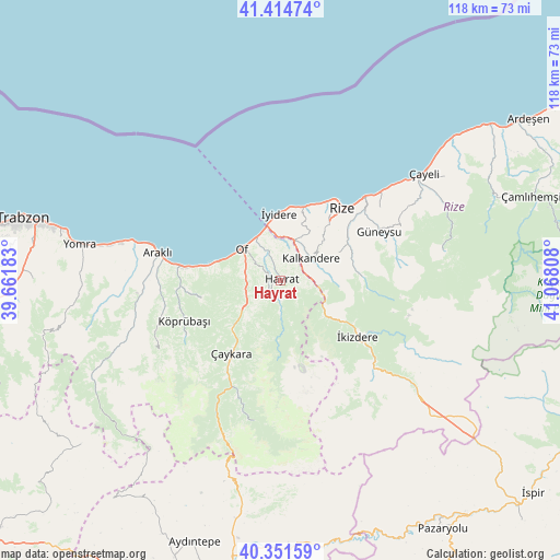
Hayrat GPS coordinates[2]
40° 53' 7.08" North, 40° 21' 53.82" East
| Map corner | latitude | longitude |
|---|---|---|
| Upper-left | 41.41474°, | 39.66183° |
| Center: | 40.8853°, | 40.36495° |
| Lower-right: | 40.35159°, | 41.06808° |
| Map W x H: | 118.2×118.2 km | = 73.4×73.4mi |
| max Lat: | 42.02683° ⇑14.2% North |
| Hayrat: | 40.8853° |
| min Lat: | ⇓85.8% South 35.9025° |
| min Long | Hayrat | max Long |
| 25.90902° | 40.36495° | 44.60099° |
| W 75.6%⇐ | ⇒24.4% E |
Elevation
Elevation of Hayrat is 229 m = 751 ft, and this is 488.4 m = 1602 ft below average elevation for this country.
| Max E: |
2682 m = 8799 ft | 72.3% |
| Avg. | 717.4 m = 2354 ft | |
| Hayrat | 229 m = 751 ft | |
Min E: |
0 m = 0 ft | 27.7% |
See also: Turkey elevation on elevation.city.
Geographical zone
Hayrat is located in North temperate zone (between Tropic of Cancer and the Arctic Circle). Distance of this Northern Tropic circle is 1940.1 km =1205.5 mi to South.| Distance of | km | miles | from Hayrat |
|---|---|---|---|
| North Pole | 5461 | 3393.3 | to North |
| Arctic Circle | 2855.2 | 1774.1 | to North |
| Tropic Cancer | 1940.1 | 1205.5 | to South |
| Equator | 4546 | 2824.8 | to South |


Nearby cities:
15 places around Hayrat: (largest is in red/bold)
• Araklı
26.4 km =16.4 mi,  282°
282°
• Derepazarı
16.2 km =10.1 mi,  17°
17°
• Dernekpazarı
14.1 km =8.8 mi,  225°
225°
• Gündoğdu
27.6 km =17.1 mi,  47°
47°
• Güneyce
11.4 km =7.1 mi,  128°
128°
• Güneysu
22.8 km =14.2 mi,  62°
62°
• Kalkandere
7.2 km =4.5 mi, 57°
• Köprübaşı
22.8 km =14.2 mi,  247°
247°
• Küçükdere
27.5 km =17.1 mi, 251°
• Of
10.8 km =6.7 mi,  304°
304°
• Rize
20 km =12.4 mi,  41°
41°
• Sürmene
20.1 km =12.5 mi, 276°
• Çaykara
19.4 km =12.1 mi,  215°
215°
• İkizdere
20 km =12.4 mi, 127°
• İyidere
14.1 km =8.8 mi,  358°
358°
Sources, notices
• [Note1] Compared only with cities in Turkey existing in our database
• [Src1] Map data: © OpenStreetMap contributors (CC-BY-SA)
• [Src2] Other city data from geonames.org with taken over terms of usage.
• [Src3] Geographical zone / Annual Mean Temperature by Robert A. Rohde @ Wikipedia
