Derepazarı geodata
Derepazarı (Rize) is a seat of a second-order administrative division; located in Turkey in Europe/Istanbul (GMT+3) time zone. In our database, there are 1323 cities with bigger population. Compared to other cities in Turkey, 90.1% of cities are located further ↓South; 75.9% of cities are located further ←West and 97.8% of cities have higher elevation than Derepazarı. Note1


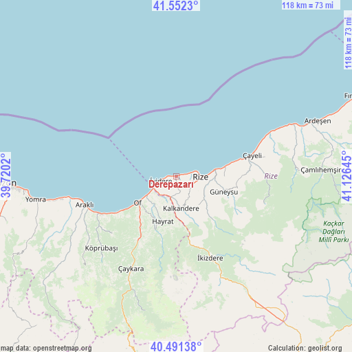
Derepazarı GPS coordinates[2]
41° 1' 26.328" North, 40° 25' 23.952" East
| Map corner | latitude | longitude |
|---|---|---|
| Upper-left | 41.5523°, | 39.7202° |
| Center: | 41.02398°, | 40.42332° |
| Lower-right: | 40.49138°, | 41.12645° |
| Map W x H: | 118×118 km | = 73.3×73.3mi |
| max Lat: | 42.02683° ⇑9.9% North |
| Derepazarı: | 41.02398° |
| min Lat: | ⇓90.1% South 35.9025° |
| min Long | Derepazarı | max Long |
| 25.90902° | 40.42332° | 44.60099° |
| W 75.9%⇐ | ⇒24.1% E |
Elevation
Elevation of Derepazarı is 10 m = 33 ft, and this is 707.4 m = 2321 ft below average elevation for this country.
| Max E: |
2682 m = 8799 ft | 97.8% |
| Avg. | 717.4 m = 2354 ft | |
| Derepazarı | 10 m = 33 ft | |
Min E: |
0 m = 0 ft | 2.2% |
See also: Turkey elevation on elevation.city.
Geographical zone
Derepazarı is located in North temperate zone (between Tropic of Cancer and the Arctic Circle). Distance of this Northern Tropic circle is 1955.5 km =1215.1 mi to South.| Distance of | km | miles | from Derepazarı |
|---|---|---|---|
| North Pole | 5445.6 | 3383.7 | to North |
| Arctic Circle | 2839.7 | 1764.5 | to North |
| Tropic Cancer | 1955.5 | 1215.1 | to South |
| Equator | 4561.4 | 2834.3 | to South |


Nearby cities:
15 places around Derepazarı: (largest is in red/bold)
• Araklı
32.1 km =19.9 mi,  252°
252°
• Büyükköy
21 km =13 mi,  92°
92°
• Dernekpazarı
29.4 km =18.3 mi,  210°
210°
• Gündoğdu
15.7 km =9.8 mi,  78°
78°
• Güneyce
22.9 km =14.2 mi,  170°
170°
• Güneysu
15.9 km =9.9 mi,  107°
107°
• Hayrat
16.2 km =10.1 mi,  197°
197°
• Kalkandere
11.6 km =7.2 mi, 174°
• Kaptanpaşa
30.9 km =19.2 mi,  103°
103°
• Of
16.6 km =10.3 mi,  236°
236°
• Rize
8.3 km =5.2 mi, 92°
• Sürmene
28.1 km =17.5 mi, 242°
• Çayeli
26 km =16.2 mi,  74°
74°
• İkizdere
29.7 km =18.5 mi,  158°
158°
• İyidere
5.3 km =3.3 mi,  255°
255°
Sources, notices
• [Note1] Compared only with cities in Turkey existing in our database
• [Src1] Map data: © OpenStreetMap contributors (CC-BY-SA)
• [Src2] Other city data from geonames.org with taken over terms of usage.
• [Src3] Geographical zone / Annual Mean Temperature by Robert A. Rohde @ Wikipedia
