Sürmene geodata
Sürmene (Trabzon) is a seat of a second-order administrative division; located in Turkey in Europe/Istanbul (GMT+3) time zone. With population of 20,039 people, there are 331 cities with bigger population in this country. Compared to other cities in Turkey, 86.3% of cities are located further ↓South; 74.3% of cities are located further ←West and 83.9% of cities have higher elevation than Sürmene. Note1


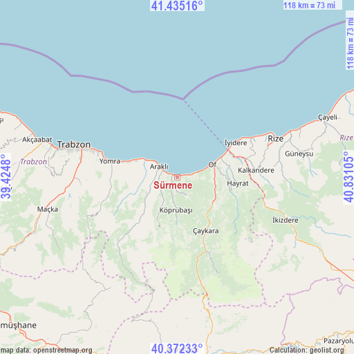
Sürmene GPS coordinates[2]
40° 54' 21.168" North, 40° 7' 40.512" East
| Map corner | latitude | longitude |
|---|---|---|
| Upper-left | 41.43516°, | 39.4248° |
| Center: | 40.90588°, | 40.12792° |
| Lower-right: | 40.37233°, | 40.83105° |
| Map W x H: | 118.2×118.2 km | = 73.4×73.4mi |
| max Lat: | 42.02683° ⇑13.7% North |
| Sürmene: | 40.90588° |
| min Lat: | ⇓86.3% South 35.9025° |
| min Long | Sürmene | max Long |
| 25.90902° | 40.12792° | 44.60099° |
| W 74.3%⇐ | ⇒25.7% E |
Elevation
Elevation of Sürmene is 81 m = 266 ft, and this is 636.4 m = 2088 ft below average elevation for this country.
| Max E: |
2682 m = 8799 ft | 83.9% |
| Avg. | 717.4 m = 2354 ft | |
| Sürmene | 81 m = 266 ft | |
Min E: |
0 m = 0 ft | 16.1% |
See also: Turkey elevation on elevation.city.
Geographical zone
Sürmene is located in North temperate zone (between Tropic of Cancer and the Arctic Circle). Distance of this Northern Tropic circle is 1942.4 km =1207 mi to South.| Distance of | km | miles | from Sürmene |
|---|---|---|---|
| North Pole | 5458.8 | 3391.9 | to North |
| Arctic Circle | 2852.9 | 1772.7 | to North |
| Tropic Cancer | 1942.4 | 1207 | to South |
| Equator | 4548.3 | 2826.2 | to South |


Nearby cities:
15 places around Sürmene: (largest is in red/bold)
• Araklı
6.9 km =4.3 mi,  301°
301°
• Arsin
17.7 km =11 mi,  287°
287°
• Dağbaşı
26.9 km =16.7 mi,  222°
222°
• Derepazarı
28.1 km =17.5 mi,  62°
62°
• Dernekpazarı
15.6 km =9.7 mi,  141°
141°
• Güneyce
30.3 km =18.8 mi,  108°
108°
• Hayrat
20.1 km =12.5 mi,  96°
96°
• Kalkandere
26 km =16.2 mi,  86°
86°
• Köprübaşı
11.1 km =6.9 mi,  185°
185°
• Küçükdere
12.5 km =7.8 mi,  209°
209°
• Of
11.7 km =7.3 mi,  70°
70°
• Yomra
23.5 km =14.6 mi,  282°
282°
• Çaykara
20.1 km =12.5 mi,  154°
154°
• Çağlayan
34.9 km =21.7 mi,  268°
268°
• İyidere
22.9 km =14.2 mi, 59°
Sources, notices
• [Note1] Compared only with cities in Turkey existing in our database
• [Src1] Map data: © OpenStreetMap contributors (CC-BY-SA)
• [Src2] Other city data from geonames.org with taken over terms of usage.
• [Src3] Geographical zone / Annual Mean Temperature by Robert A. Rohde @ Wikipedia
