Güneyce geodata
Güneyce (Rize) is a seat of a third-order administrative division; located in Turkey in Europe/Istanbul (GMT+3) time zone. In our database, there are 1323 cities with bigger population. Compared to other cities in Turkey, 84.2% of cities are located further ↓South; 76.1% of cities are located further ←West and 56.2% of cities have higher elevation than Güneyce. Note1


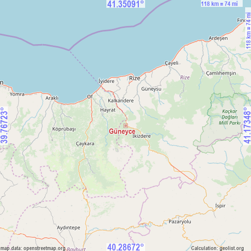
Güneyce GPS coordinates[2]
40° 49' 15.42" North, 40° 28' 13.26" East
| Map corner | latitude | longitude |
|---|---|---|
| Upper-left | 41.35091°, | 39.76723° |
| Center: | 40.82095°, | 40.47035° |
| Lower-right: | 40.28672°, | 41.17348° |
| Map W x H: | 118.3×118.3 km | = 73.5×73.5mi |
| max Lat: | 42.02683° ⇑15.8% North |
| Güneyce: | 40.82095° |
| min Lat: | ⇓84.2% South 35.9025° |
| min Long | Güneyce | max Long |
| 25.90902° | 40.47035° | 44.60099° |
| W 76.1%⇐ | ⇒23.9% E |
Elevation
Elevation of Güneyce is 566 m = 1857 ft, and this is 151.4 m = 497 ft below average elevation for this country.
| Max E: |
2682 m = 8799 ft | 56.2% |
| Avg. | 717.4 m = 2354 ft | |
| Güneyce | 566 m = 1857 ft | |
Min E: |
0 m = 0 ft | 43.8% |
See also: Turkey elevation on elevation.city.
Geographical zone
Güneyce is located in North temperate zone (between Tropic of Cancer and the Arctic Circle). Distance of this Northern Tropic circle is 1932.9 km =1201 mi to South.| Distance of | km | miles | from Güneyce |
|---|---|---|---|
| North Pole | 5468.2 | 3397.8 | to North |
| Arctic Circle | 2862.3 | 1778.6 | to North |
| Tropic Cancer | 1932.9 | 1201 | to South |
| Equator | 4538.9 | 2820.3 | to South |


Nearby cities:
15 places around Güneyce: (largest is in red/bold)
• Büyükköy
27.5 km =17.1 mi,  38°
38°
• Derepazarı
22.9 km =14.2 mi,  350°
350°
• Dernekpazarı
19.2 km =11.9 mi,  261°
261°
• Gündoğdu
28.2 km =17.5 mi,  23°
23°
• Güneysu
21.1 km =13.1 mi,  32°
32°
• Hayrat
11.4 km =7.1 mi,  308°
308°
• Kalkandere
11.4 km =7.1 mi, 345°
• Köprübaşı
30 km =18.6 mi,  267°
267°
• Of
22.2 km =13.8 mi, 306°
• Rize
22.6 km =14 mi,  11°
11°
• Sürmene
30.3 km =18.8 mi,  288°
288°
• Uzungöl
27.5 km =17.1 mi,  213°
213°
• Çaykara
21.9 km =13.6 mi,  246°
246°
• İkizdere
8.6 km =5.3 mi,  126°
126°
• İyidere
23.1 km =14.4 mi,  336°
336°
Sources, notices
• [Note1] Compared only with cities in Turkey existing in our database
• [Src1] Map data: © OpenStreetMap contributors (CC-BY-SA)
• [Src2] Other city data from geonames.org with taken over terms of usage.
• [Src3] Geographical zone / Annual Mean Temperature by Robert A. Rohde @ Wikipedia
