Çaykara geodata
Çaykara (Trabzon) is a seat of a second-order administrative division; located in Turkey in Europe/Istanbul (GMT+3) time zone. With population of 14,398 people, there are 402 cities with bigger population in this country. Compared to other cities in Turkey, 82.2% of cities are located further ↓South; 75.2% of cities are located further ←West and 54.6% of cities have higher elevation than Çaykara. Note1


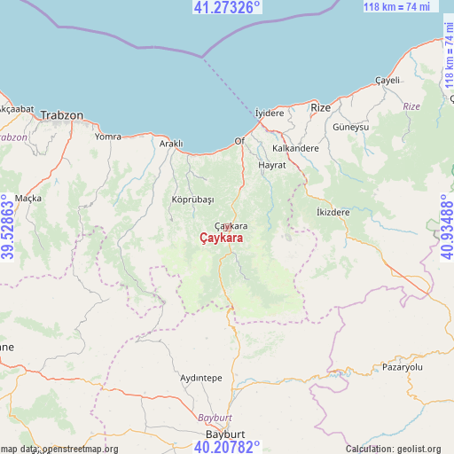
Çaykara GPS coordinates[2]
40° 44' 33.612" North, 40° 13' 54.3" East
| Map corner | latitude | longitude |
|---|---|---|
| Upper-left | 41.27326°, | 39.52863° |
| Center: | 40.74267°, | 40.23175° |
| Lower-right: | 40.20782°, | 40.93488° |
| Map W x H: | 118.5×118.5 km | = 73.6×73.6mi |
| max Lat: | 42.02683° ⇑17.8% North |
| Çaykara: | 40.74267° |
| min Lat: | ⇓82.2% South 35.9025° |
| min Long | Çaykara | max Long |
| 25.90902° | 40.23175° | 44.60099° |
| W 75.2%⇐ | ⇒24.8% E |
Elevation
Elevation of Çaykara is 601 m = 1972 ft, and this is 116.4 m = 382 ft below average elevation for this country.
| Max E: |
2682 m = 8799 ft | 54.6% |
| Avg. | 717.4 m = 2354 ft | |
| Çaykara | 601 m = 1972 ft | |
Min E: |
0 m = 0 ft | 45.4% |
See also: Turkey elevation on elevation.city.
Geographical zone
Çaykara is located in North temperate zone (between Tropic of Cancer and the Arctic Circle). Distance of this Northern Tropic circle is 1924.2 km =1195.6 mi to South.| Distance of | km | miles | from Çaykara |
|---|---|---|---|
| North Pole | 5476.9 | 3403.2 | to North |
| Arctic Circle | 2871 | 1784 | to North |
| Tropic Cancer | 1924.2 | 1195.6 | to South |
| Equator | 4530.2 | 2814.9 | to South |


Nearby cities:
15 places around Çaykara: (largest is in red/bold)
• Araklı
26.2 km =16.3 mi,  326°
326°
• Arsin
34.7 km =21.6 mi,  312°
312°
• Dağbaşı
27 km =16.8 mi,  266°
266°
• Derepazarı
35.2 km =21.9 mi,  27°
27°
• Dernekpazarı
6.1 km =3.8 mi,  10°
10°
• Güneyce
21.9 km =13.6 mi,  66°
66°
• Hayrat
19.4 km =12.1 mi,  35°
35°
• Kalkandere
26.2 km =16.3 mi, 41°
• Köprübaşı
12.2 km =7.6 mi, 305°
• Küçükdere
16.5 km =10.3 mi,  295°
295°
• Of
22.1 km =13.7 mi, 5°
• Sürmene
20.1 km =12.5 mi, 334°
• Uzungöl
14.9 km =9.3 mi,  161°
161°
• İkizdere
27.2 km =16.9 mi,  82°
82°
• İyidere
31.9 km =19.8 mi,  20°
20°
Sources, notices
• [Note1] Compared only with cities in Turkey existing in our database
• [Src1] Map data: © OpenStreetMap contributors (CC-BY-SA)
• [Src2] Other city data from geonames.org with taken over terms of usage.
• [Src3] Geographical zone / Annual Mean Temperature by Robert A. Rohde @ Wikipedia
