Gümüş geodata
Gümüş (Amasya) is a seat of a third-order administrative division; located in Turkey in Europe/Istanbul (GMT+3) time zone. In our database, there are 1323 cities with bigger population. Compared to other cities in Turkey, 84.5% of cities are located further ↓South; 53.6% of cities are located further →East and 59.6% of cities have lower elevation than Gümüş. Note1


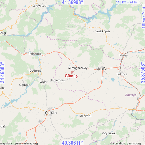
Gümüş GPS coordinates[2]
40° 50' 24.648" North, 35° 10' 19.02" East
| Map corner | latitude | longitude |
|---|---|---|
| Upper-left | 41.36998°, | 34.46883° |
| Center: | 40.84018°, | 35.17195° |
| Lower-right: | 40.30611°, | 35.87508° |
| Map W x H: | 118.3×118.3 km | = 73.5×73.5mi |
| max Lat: | 42.02683° ⇑15.5% North |
| Gümüş: | 40.84018° |
| min Lat: | ⇓84.5% South 35.9025° |
| min Long | Gümüş | max Long |
| 25.90902° | 35.17195° | 44.60099° |
| W 46.4%⇐ | ⇒53.6% E |
Elevation
Elevation of Gümüş is 875 m = 2871 ft, and this is 157.6 m = 517 ft above average elevation for this country.
| Max E: |
2682 m = 8799 ft | 40.4% |
| Gümüş | 875 m 2871 ft | |
| Avg. | 717.4 m = 2354 ft | |
Min E: |
0 m = 0 ft | 59.6% |
See also: Turkey elevation on elevation.city.
Geographical zone
Gümüş is located in North temperate zone (between Tropic of Cancer and the Arctic Circle). Distance of this Northern Tropic circle is 1935.1 km =1202.4 mi to South.| Distance of | km | miles | from Gümüş |
|---|---|---|---|
| North Pole | 5466.1 | 3396.5 | to North |
| Arctic Circle | 2860.2 | 1777.2 | to North |
| Tropic Cancer | 1935.1 | 1202.4 | to South |
| Equator | 4541 | 2821.6 | to South |


Nearby cities:
15 places around Gümüş: (largest is in red/bold)
• Alıcık
13.3 km =8.3 mi,  108°
108°
• Beşpınar
33.4 km =20.8 mi,  6°
6°
• Dedeköy
15 km =9.3 mi,  226°
226°
• Dodurga
30.7 km =19.1 mi,  273°
273°
• Gümüşhacıköy
5.1 km =3.2 mi,  44°
44°
• Hamamözü
13.8 km =8.6 mi,  243°
243°
• Köprübaşı
37 km =23 mi,  51°
51°
• Laçin
25.6 km =15.9 mi,  253°
253°
• Mecitözü
37.1 km =23.1 mi,  163°
163°
• Merzifon
24.8 km =15.4 mi,  81°
81°
• Osmancık
34.5 km =21.4 mi,  296°
296°
• Saraycık
13.2 km =8.2 mi,  337°
337°
• Sarıbuğday
26.3 km =16.3 mi, 112°
• Suluova
40 km =24.9 mi,  91°
91°
• Çorum
37.3 km =23.2 mi,  209°
209°
Sources, notices
• [Note1] Compared only with cities in Turkey existing in our database
• [Src1] Map data: © OpenStreetMap contributors (CC-BY-SA)
• [Src2] Other city data from geonames.org with taken over terms of usage.
• [Src3] Geographical zone / Annual Mean Temperature by Robert A. Rohde @ Wikipedia
