Merzifon geodata
Merzifon (Amasya) is a seat of a second-order administrative division; located in Turkey in Europe/Istanbul (GMT+3) time zone. With population of 50,658 people, there are 169 cities with bigger population in this country. Compared to other cities in Turkey, 85.4% of cities are located further ↓South; 52.3% of cities are located further →East and 51.7% of cities have lower elevation than Merzifon. Note1


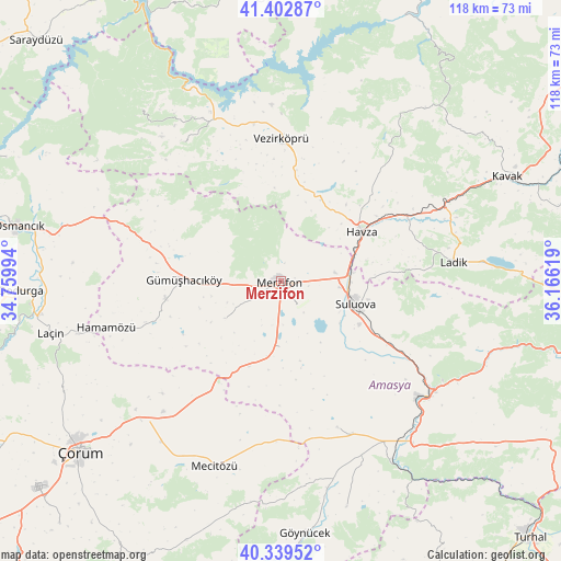
Merzifon GPS coordinates[2]
40° 52' 23.988" North, 35° 27' 47.016" East
| Map corner | latitude | longitude |
|---|---|---|
| Upper-left | 41.40287°, | 34.75994° |
| Center: | 40.87333°, | 35.46306° |
| Lower-right: | 40.33952°, | 36.16619° |
| Map W x H: | 118.2×118.2 km | = 73.4×73.4mi |
| max Lat: | 42.02683° ⇑14.6% North |
| Merzifon: | 40.87333° |
| min Lat: | ⇓85.4% South 35.9025° |
| min Long | Merzifon | max Long |
| 25.90902° | 35.46306° | 44.60099° |
| W 47.7%⇐ | ⇒52.3% E |
Elevation
Elevation of Merzifon is 732 m = 2402 ft, and this is 14.6 m = 48 ft above average elevation for this country.
| Max E: |
2682 m = 8799 ft | 48.3% |
| Merzifon | 732 m 2402 ft | |
| Avg. | 717.4 m = 2354 ft | |
Min E: |
0 m = 0 ft | 51.7% |
See also: Merzifon elevation on elevation.city.
Geographical zone
Merzifon is located in North temperate zone (between Tropic of Cancer and the Arctic Circle). Distance of this Northern Tropic circle is 1938.8 km =1204.7 mi to South.| Distance of | km | miles | from Merzifon |
|---|---|---|---|
| North Pole | 5462.4 | 3394.2 | to North |
| Arctic Circle | 2856.5 | 1774.9 | to North |
| Tropic Cancer | 1938.8 | 1204.7 | to South |
| Equator | 4544.7 | 2823.9 | to South |


Nearby cities:
15 places around Merzifon: (largest is in red/bold)
• Alıcık
14.2 km =8.8 mi,  236°
236°
• Amasya
39.6 km =24.6 mi,  128°
128°
• Beşpınar
36 km =22.4 mi,  324°
324°
• Dedeköy
38.1 km =23.7 mi,  248°
248°
• Doğantepe
32.9 km =20.4 mi,  158°
158°
• Gümüş
24.8 km =15.4 mi,  261°
261°
• Gümüşhacıköy
20.9 km =13 mi,  269°
269°
• Hamamözü
38.1 km =23.7 mi, 255°
• Havza
19.9 km =12.4 mi,  57°
57°
• Köprübaşı
19.9 km =12.4 mi,  13°
13°
• Ladik
36.3 km =22.6 mi,  83°
83°
• Saraycık
30.7 km =19.1 mi,  286°
286°
• Sarıbuğday
13.9 km =8.6 mi,  181°
181°
• Suluova
16.2 km =10.1 mi,  106°
106°
• Vezirköprü
30.1 km =18.7 mi,  358°
358°
Sources, notices
• [Note1] Compared only with cities in Turkey existing in our database
• [Src1] Map data: © OpenStreetMap contributors (CC-BY-SA)
• [Src2] Other city data from geonames.org with taken over terms of usage.
• [Src3] Geographical zone / Annual Mean Temperature by Robert A. Rohde @ Wikipedia
