Çorum geodata
Çorum is a seat of a first-order administrative division; located in Turkey in Europe/Istanbul (GMT+3) time zone. With population of 183,418 people, there are 55 cities with bigger population in this country. Compared to other cities in Turkey, 78.4% of cities are located further ↓South; 54.5% of cities are located further →East and 55.9% of cities have lower elevation than Çorum. Note1


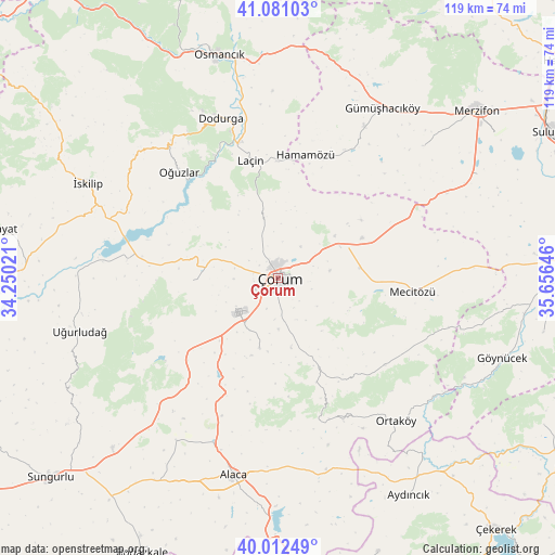
Çorum GPS coordinates[2]
40° 32' 56.004" North, 34° 57' 11.988" East
| Map corner | latitude | longitude |
|---|---|---|
| Upper-left | 41.08103°, | 34.25021° |
| Center: | 40.54889°, | 34.95333° |
| Lower-right: | 40.01249°, | 35.65646° |
| Map W x H: | 118.8×118.8 km | = 73.8×73.8mi |
| max Lat: | 42.02683° ⇑21.6% North |
| Çorum: | 40.54889° |
| min Lat: | ⇓78.4% South 35.9025° |
| min Long | Çorum | max Long |
| 25.90902° | 34.95333° | 44.60099° |
| W 45.5%⇐ | ⇒54.5% E |
Elevation
Elevation of Çorum is 808 m = 2651 ft, and this is 90.6 m = 297 ft above average elevation for this country.
| Max E: |
2682 m = 8799 ft | 44.1% |
| Çorum | 808 m 2651 ft | |
| Avg. | 717.4 m = 2354 ft | |
Min E: |
0 m = 0 ft | 55.9% |
See also: Çorum elevation on elevation.city.
Geographical zone
Çorum is located in North temperate zone (between Tropic of Cancer and the Arctic Circle). Distance of this Northern Tropic circle is 1902.7 km =1182.3 mi to South.| Distance of | km | miles | from Çorum |
|---|---|---|---|
| North Pole | 5498.4 | 3416.5 | to North |
| Arctic Circle | 2892.6 | 1797.4 | to North |
| Tropic Cancer | 1902.7 | 1182.3 | to South |
| Equator | 4508.6 | 2801.5 | to South |


Nearby cities:
15 places around Çorum: (largest is in red/bold)
• Alaca
43.3 km =26.9 mi,  192°
192°
• Alıcık
42 km =26.1 mi,  47°
47°
• Cemilbey
24.1 km =15 mi,  159°
159°
• Dedeköy
23.3 km =14.5 mi,  18°
18°
• Dodurga
36.2 km =22.5 mi,  340°
340°
• Gümüş
37.3 km =23.2 mi,  29°
29°
• Gümüşhacıköy
42.2 km =26.2 mi, 31°
• Hamamözü
26.9 km =16.7 mi,  13°
13°
• Laçin
25.9 km =16.1 mi,  346°
346°
• Mecitözü
29.1 km =18.1 mi,  96°
96°
• Ortaköy
39.7 km =24.7 mi,  140°
140°
• Oğuzlar
31.1 km =19.3 mi,  317°
317°
• Seydim
18.2 km =11.3 mi,  267°
267°
• Uğurludağ
43.8 km =27.2 mi,  254°
254°
• İskilip
45.5 km =28.3 mi,  297°
297°
Sources, notices
• [Note1] Compared only with cities in Turkey existing in our database
• [Src1] Map data: © OpenStreetMap contributors (CC-BY-SA)
• [Src2] Other city data from geonames.org with taken over terms of usage.
• [Src3] Geographical zone / Annual Mean Temperature by Robert A. Rohde @ Wikipedia
