Dodurga geodata
Dodurga (Çorum) is a seat of a second-order administrative division; located in Turkey in Europe/Istanbul (GMT+3) time zone. In our database, there are 1323 cities with bigger population. Compared to other cities in Turkey, 84.9% of cities are located further ↓South; 55.1% of cities are located further →East and 56.1% of cities have higher elevation than Dodurga. Note1


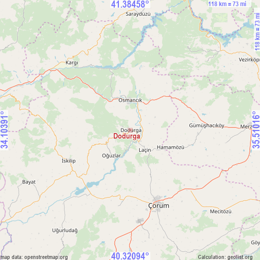
Dodurga GPS coordinates[2]
40° 51' 17.604" North, 34° 48' 25.308" East
| Map corner | latitude | longitude |
|---|---|---|
| Upper-left | 41.38458°, | 34.10391° |
| Center: | 40.85489°, | 34.80703° |
| Lower-right: | 40.32094°, | 35.51016° |
| Map W x H: | 118.3×118.3 km | = 73.5×73.5mi |
| max Lat: | 42.02683° ⇑15.1% North |
| Dodurga: | 40.85489° |
| min Lat: | ⇓84.9% South 35.9025° |
| min Long | Dodurga | max Long |
| 25.90902° | 34.80703° | 44.60099° |
| W 44.9%⇐ | ⇒55.1% E |
Elevation
Elevation of Dodurga is 568 m = 1864 ft, and this is 149.4 m = 490 ft below average elevation for this country.
| Max E: |
2682 m = 8799 ft | 56.1% |
| Avg. | 717.4 m = 2354 ft | |
| Dodurga | 568 m = 1864 ft | |
Min E: |
0 m = 0 ft | 43.9% |
See also: Turkey elevation on elevation.city.
Geographical zone
Dodurga is located in North temperate zone (between Tropic of Cancer and the Arctic Circle). Distance of this Northern Tropic circle is 1936.7 km =1203.4 mi to South.| Distance of | km | miles | from Dodurga |
|---|---|---|---|
| North Pole | 5464.4 | 3395.4 | to North |
| Arctic Circle | 2858.5 | 1776.2 | to North |
| Tropic Cancer | 1936.7 | 1203.4 | to South |
| Equator | 4542.6 | 2822.6 | to South |


Nearby cities:
15 places around Dodurga: (largest is in red/bold)
• Alıcık
43.8 km =27.2 mi,  97°
97°
• Dedeköy
23.1 km =14.4 mi,  121°
121°
• Gümüş
30.7 km =19.1 mi,  93°
93°
• Gümüşhacıköy
34.3 km =21.3 mi, 86°
• Hacıhamza
38.7 km =24 mi,  309°
309°
• Hamamözü
20 km =12.4 mi,  112°
112°
• Kargı
41 km =25.5 mi,  319°
319°
• Kâmil
27.9 km =17.3 mi,  352°
352°
• Laçin
10.8 km =6.7 mi,  145°
145°
• Osmancık
13.7 km =8.5 mi,  359°
359°
• Oğuzlar
14.3 km =8.9 mi,  217°
217°
• Saraycık
27.7 km =17.2 mi,  67°
67°
• Seydim
35.2 km =21.9 mi,  189°
189°
• Çorum
36.2 km =22.5 mi,  160°
160°
• İskilip
31 km =19.3 mi,  244°
244°
Sources, notices
• [Note1] Compared only with cities in Turkey existing in our database
• [Src1] Map data: © OpenStreetMap contributors (CC-BY-SA)
• [Src2] Other city data from geonames.org with taken over terms of usage.
• [Src3] Geographical zone / Annual Mean Temperature by Robert A. Rohde @ Wikipedia
