Osmancık geodata
Osmancık (Çorum) is a seat of a second-order administrative division; located in Turkey in Europe/Istanbul (GMT+3) time zone. With population of 36,443 people, there are 218 cities with bigger population in this country. Compared to other cities in Turkey, 88.4% of cities are located further ↓South; 55.2% of cities are located further →East and 64.7% of cities have higher elevation than Osmancık. Note1


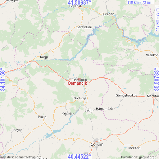
Osmancık GPS coordinates[2]
40° 58' 41.448" North, 34° 48' 16.92" East
| Map corner | latitude | longitude |
|---|---|---|
| Upper-left | 41.50687°, | 34.10158° |
| Center: | 40.97818°, | 34.8047° |
| Lower-right: | 40.44522°, | 35.50783° |
| Map W x H: | 118×118 km | = 73.3×73.3mi |
| max Lat: | 42.02683° ⇑11.6% North |
| Osmancık: | 40.97818° |
| min Lat: | ⇓88.4% South 35.9025° |
| min Long | Osmancık | max Long |
| 25.90902° | 34.8047° | 44.60099° |
| W 44.8%⇐ | ⇒55.2% E |
Elevation
Elevation of Osmancık is 424 m = 1391 ft, and this is 293.4 m = 963 ft below average elevation for this country.
| Max E: |
2682 m = 8799 ft | 64.7% |
| Avg. | 717.4 m = 2354 ft | |
| Osmancık | 424 m = 1391 ft | |
Min E: |
0 m = 0 ft | 35.3% |
See also: Turkey elevation on elevation.city.
Geographical zone
Osmancık is located in North temperate zone (between Tropic of Cancer and the Arctic Circle). Distance of this Northern Tropic circle is 1950.4 km =1211.9 mi to South.| Distance of | km | miles | from Osmancık |
|---|---|---|---|
| North Pole | 5450.7 | 3386.9 | to North |
| Arctic Circle | 2844.8 | 1767.7 | to North |
| Tropic Cancer | 1950.4 | 1211.9 | to South |
| Equator | 4556.3 | 2831.2 | to South |


Nearby cities:
15 places around Osmancık: (largest is in red/bold)
• Beşpınar
38.9 km =24.2 mi,  62°
62°
• Dedeköy
32.5 km =20.2 mi,  142°
142°
• Dodurga
13.7 km =8.5 mi,  179°
179°
• Gümüş
34.5 km =21.4 mi,  116°
116°
• Gümüşhacıköy
36.4 km =22.6 mi,  108°
108°
• Hacıhamza
31.7 km =19.7 mi,  289°
289°
• Hamamözü
28.4 km =17.6 mi, 139°
• Kargı
31.7 km =19.7 mi,  303°
303°
• Kâmil
14.4 km =8.9 mi,  345°
345°
• Laçin
23.5 km =14.6 mi,  164°
164°
• Mezraa
35.8 km =22.2 mi,  46°
46°
• Oğuzlar
26.4 km =16.4 mi,  198°
198°
• Saraycık
26 km =16.2 mi,  96°
96°
• Saraydüzü
39.1 km =24.3 mi,  5°
5°
• İskilip
38.8 km =24.1 mi,  225°
225°
Sources, notices
• [Note1] Compared only with cities in Turkey existing in our database
• [Src1] Map data: © OpenStreetMap contributors (CC-BY-SA)
• [Src2] Other city data from geonames.org with taken over terms of usage.
• [Src3] Geographical zone / Annual Mean Temperature by Robert A. Rohde @ Wikipedia
