Görükle geodata
Görükle (Bursa) is a seat of a third-order administrative division; located in Turkey in Europe/Istanbul (GMT+3) time zone. In our database, there are 1323 cities with bigger population. Compared to other cities in Turkey, 73.2% of cities are located further ↓South; 85.3% of cities are located further →East and 79.2% of cities have higher elevation than Görükle. Note1


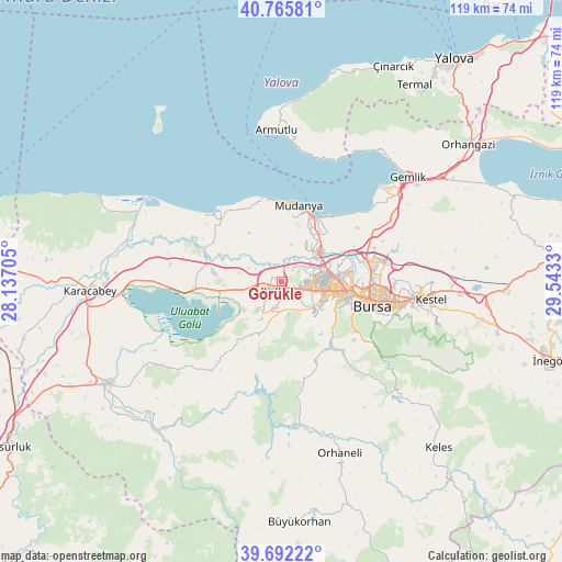
Görükle GPS coordinates[2]
40° 13' 52.104" North, 28° 50' 24.612" East
| Map corner | latitude | longitude |
|---|---|---|
| Upper-left | 40.76581°, | 28.13705° |
| Center: | 40.23114°, | 28.84017° |
| Lower-right: | 39.69222°, | 29.5433° |
| Map W x H: | 119.4×119.4 km | = 74.2×74.2mi |
| max Lat: | 42.02683° ⇑26.8% North |
| Görükle: | 40.23114° |
| min Lat: | ⇓73.2% South 35.9025° |
| min Long | Görükle | max Long |
| 25.90902° | 28.84017° | 44.60099° |
| W 14.7%⇐ | ⇒85.3% E |
Elevation
Elevation of Görükle is 121 m = 397 ft, and this is 596.4 m = 1957 ft below average elevation for this country.
| Max E: |
2682 m = 8799 ft | 79.2% |
| Avg. | 717.4 m = 2354 ft | |
| Görükle | 121 m = 397 ft | |
Min E: |
0 m = 0 ft | 20.8% |
See also: Turkey elevation on elevation.city.
Geographical zone
Görükle is located in North temperate zone (between Tropic of Cancer and the Arctic Circle). Distance of this Northern Tropic circle is 1867.4 km =1160.3 mi to South.| Distance of | km | miles | from Görükle |
|---|---|---|---|
| North Pole | 5533.8 | 3438.5 | to North |
| Arctic Circle | 2927.9 | 1819.3 | to North |
| Tropic Cancer | 1867.4 | 1160.3 | to South |
| Equator | 4473.3 | 2779.6 | to South |


Nearby cities:
15 places around Görükle: (largest is in red/bold)
• Bursa
19.1 km =11.9 mi,  101°
101°
• Demirtaş
22.4 km =13.9 mi,  78°
78°
• Gürsu
30.1 km =18.7 mi,  92°
92°
• Karıncalı
28.9 km =18 mi,  176°
176°
• Kestel
31.8 km =19.8 mi, 96°
• Kirazlı
22.5 km =14 mi,  130°
130°
• Mahmudiye
20.1 km =12.5 mi,  306°
306°
• Mudanya
16.4 km =10.2 mi,  12°
12°
• Nilüfer
6.7 km =4.2 mi,  106°
106°
• Osmangazi
19 km =11.8 mi, 101°
• Soldere
29.6 km =18.4 mi,  230°
230°
• Soğukpınar
31 km =19.3 mi, 129°
• Yıldırım
23.4 km =14.5 mi, 101°
• Zeytinbağı
18.1 km =11.2 mi,  348°
348°
• Çalı
9.8 km =6.1 mi,  135°
135°
Sources, notices
• [Note1] Compared only with cities in Turkey existing in our database
• [Src1] Map data: © OpenStreetMap contributors (CC-BY-SA)
• [Src2] Other city data from geonames.org with taken over terms of usage.
• [Src3] Geographical zone / Annual Mean Temperature by Robert A. Rohde @ Wikipedia
