Zeytinbağı geodata
Zeytinbağı (Bursa) is a seat of a third-order administrative division; located in Turkey in Europe/Istanbul (GMT+3) time zone. In our database, there are 1323 cities with bigger population. Compared to other cities in Turkey, 75.8% of cities are located further ↓South; 85.6% of cities are located further →East and 88.5% of cities have higher elevation than Zeytinbağı. Note1


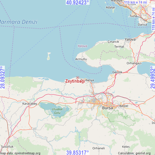
Zeytinbağı GPS coordinates[2]
40° 23' 26.988" North, 28° 47' 47.004" East
| Map corner | latitude | longitude |
|---|---|---|
| Upper-left | 40.92423°, | 28.09327° |
| Center: | 40.39083°, | 28.79639° |
| Lower-right: | 39.85317°, | 29.49952° |
| Map W x H: | 119.1×119.1 km | = 74×74mi |
| max Lat: | 42.02683° ⇑24.2% North |
| Zeytinbağı: | 40.39083° |
| min Lat: | ⇓75.8% South 35.9025° |
| min Long | Zeytinbağı | max Long |
| 25.90902° | 28.79639° | 44.60099° |
| W 14.4%⇐ | ⇒85.6% E |
Elevation
Elevation of Zeytinbağı is 47 m = 154 ft, and this is 670.4 m = 2199 ft below average elevation for this country.
| Max E: |
2682 m = 8799 ft | 88.5% |
| Avg. | 717.4 m = 2354 ft | |
| Zeytinbağı | 47 m = 154 ft | |
Min E: |
0 m = 0 ft | 11.5% |
See also: Turkey elevation on elevation.city.
Geographical zone
Zeytinbağı is located in North temperate zone (between Tropic of Cancer and the Arctic Circle). Distance of this Northern Tropic circle is 1885.1 km =1171.3 mi to South.| Distance of | km | miles | from Zeytinbağı |
|---|---|---|---|
| North Pole | 5516 | 3427.5 | to North |
| Arctic Circle | 2910.1 | 1808.3 | to North |
| Tropic Cancer | 1885.1 | 1171.3 | to South |
| Equator | 4491 | 2790.6 | to South |


Nearby cities:
15 places around Zeytinbağı: (largest is in red/bold)
• Armutlu
14.5 km =9 mi,  10°
10°
• Bursa
31.2 km =19.4 mi,  134°
134°
• Demirtaş
28.8 km =17.9 mi,  117°
117°
• Gemlik
31.1 km =19.3 mi,  81°
81°
• Görükle
18.1 km =11.2 mi,  168°
168°
• Karacaali
25 km =15.5 mi,  66°
66°
• Kocadere
33.1 km =20.6 mi,  36°
36°
• Küçükkumla
27.3 km =17 mi, 71°
• Mahmudiye
13.8 km =8.6 mi,  244°
244°
• Mudanya
7.5 km =4.7 mi,  103°
103°
• Nilüfer
22.1 km =13.7 mi,  152°
152°
• Osmangazi
31 km =19.3 mi, 134°
• Seçköy
34.7 km =21.6 mi, 102°
• Umurbey
32.8 km =20.4 mi,  85°
85°
• Çalı
26.9 km =16.7 mi,  156°
156°
Sources, notices
• [Note1] Compared only with cities in Turkey existing in our database
• [Src1] Map data: © OpenStreetMap contributors (CC-BY-SA)
• [Src2] Other city data from geonames.org with taken over terms of usage.
• [Src3] Geographical zone / Annual Mean Temperature by Robert A. Rohde @ Wikipedia
