Altınordu geodata
Altınordu (Ordu) is a seat of a second-order administrative division; located in Turkey in Europe/Istanbul (GMT+3) time zone. In our database, there are 1323 cities with bigger population. Compared to other cities in Turkey, 88.6% of cities are located further ↓South; 61.1% of cities are located further ←West and 90.7% of cities have higher elevation than Altınordu. Note1


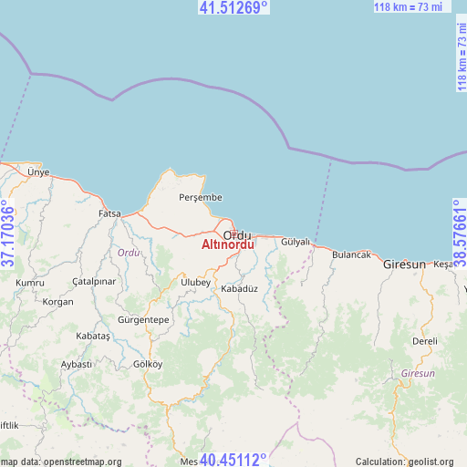
Altınordu GPS coordinates[2]
40° 59' 2.544" North, 37° 52' 24.528" East
| Map corner | latitude | longitude |
|---|---|---|
| Upper-left | 41.51269°, | 37.17036° |
| Center: | 40.98404°, | 37.87348° |
| Lower-right: | 40.45112°, | 38.57661° |
| Map W x H: | 118×118 km | = 73.3×73.3mi |
| max Lat: | 42.02683° ⇑11.4% North |
| Altınordu: | 40.98404° |
| min Lat: | ⇓88.6% South 35.9025° |
| min Long | Altınordu | max Long |
| 25.90902° | 37.87348° | 44.60099° |
| W 61.1%⇐ | ⇒38.9% E |
Elevation
Elevation of Altınordu is 36 m = 118 ft, and this is 681.4 m = 2236 ft below average elevation for this country.
| Max E: |
2682 m = 8799 ft | 90.7% |
| Avg. | 717.4 m = 2354 ft | |
| Altınordu | 36 m = 118 ft | |
Min E: |
0 m = 0 ft | 9.3% |
See also: Turkey elevation on elevation.city.
Geographical zone
Altınordu is located in North temperate zone (between Tropic of Cancer and the Arctic Circle). Distance of this Northern Tropic circle is 1951.1 km =1212.4 mi to South.| Distance of | km | miles | from Altınordu |
|---|---|---|---|
| North Pole | 5450.1 | 3386.5 | to North |
| Arctic Circle | 2844.2 | 1767.3 | to North |
| Tropic Cancer | 1951.1 | 1212.4 | to South |
| Equator | 4557 | 2831.6 | to South |


Nearby cities:
15 places around Altınordu: (largest is in red/bold)
• Bolaman
24.1 km =15 mi,  283°
283°
• Bulancak
30.5 km =19 mi,  99°
99°
• Fatsa
31.6 km =19.6 mi, 278°
• Gülyalı
15 km =9.3 mi, 99°
• Gürgentepe
32.5 km =20.2 mi,  227°
227°
• Kabadüz
13.7 km =8.5 mi,  176°
176°
• Kovanlık
32.4 km =20.1 mi,  141°
141°
• Ordu
1.6 km =1 mi,  115°
115°
• Perşembe
12.5 km =7.8 mi,  316°
316°
• Piraziz
20.1 km =12.5 mi, 99°
• Piraziz
22.2 km =13.8 mi,  107°
107°
• Ulubey
16.3 km =10.1 mi,  218°
218°
• Uzunisa
8 km =5 mi,  195°
195°
• Çamaş
30.4 km =18.9 mi,  252°
252°
• Çatalpınar
37.2 km =23.1 mi, 251°
Sources, notices
• [Note1] Compared only with cities in Turkey existing in our database
• [Src1] Map data: © OpenStreetMap contributors (CC-BY-SA)
• [Src2] Other city data from geonames.org with taken over terms of usage.
• [Src3] Geographical zone / Annual Mean Temperature by Robert A. Rohde @ Wikipedia
