Gemlik geodata
Gemlik (Bursa) is a seat of a second-order administrative division; located in Turkey in Europe/Istanbul (GMT+3) time zone. With population of 71,063 people, there are 131 cities with bigger population in this country. Compared to other cities in Turkey, 76.7% of cities are located further ↓South; 82.3% of cities are located further →East and 99.3% of cities have higher elevation than Gemlik. Note1


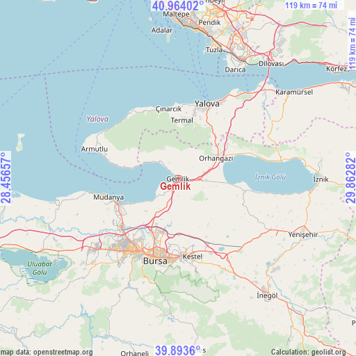
Gemlik GPS coordinates[2]
40° 25' 51.384" North, 29° 9' 34.884" East
| Map corner | latitude | longitude |
|---|---|---|
| Upper-left | 40.96402°, | 28.45657° |
| Center: | 40.43094°, | 29.15969° |
| Lower-right: | 39.8936°, | 29.86282° |
| Map W x H: | 119×119 km | = 73.9×73.9mi |
| max Lat: | 42.02683° ⇑23.3% North |
| Gemlik: | 40.43094° |
| min Lat: | ⇓76.7% South 35.9025° |
| min Long | Gemlik | max Long |
| 25.90902° | 29.15969° | 44.60099° |
| W 17.7%⇐ | ⇒82.3% E |
Elevation
Elevation of Gemlik is 5 m = 16 ft, and this is 712.4 m = 2337 ft below average elevation for this country.
| Max E: |
2682 m = 8799 ft | 99.3% |
| Avg. | 717.4 m = 2354 ft | |
| Gemlik | 5 m = 16 ft | |
Min E: |
0 m = 0 ft | 0.7% |
See also: Gemlik elevation on elevation.city.
Geographical zone
Gemlik is located in North temperate zone (between Tropic of Cancer and the Arctic Circle). Distance of this Northern Tropic circle is 1889.6 km =1174.1 mi to South.| Distance of | km | miles | from Gemlik |
|---|---|---|---|
| North Pole | 5511.6 | 3424.7 | to North |
| Arctic Circle | 2905.7 | 1805.5 | to North |
| Tropic Cancer | 1889.6 | 1174.1 | to South |
| Equator | 4495.5 | 2793.4 | to South |


Nearby cities:
15 places around Gemlik: (largest is in red/bold)
• Demirtaş
18.4 km =11.4 mi,  196°
196°
• Gürsu
23.8 km =14.8 mi,  172°
172°
• Kadıköy
21.8 km =13.5 mi,  14°
14°
• Karacaali
9.4 km =5.8 mi,  304°
304°
• Kocadere
24.7 km =15.3 mi,  333°
333°
• Koruköy
24.8 km =15.4 mi,  0°
0°
• Küçükkumla
6.6 km =4.1 mi,  311°
311°
• Mudanya
24.3 km =15.1 mi,  255°
255°
• Orhangazi
14.2 km =8.8 mi,  62°
62°
• Seçköy
12.3 km =7.6 mi, 165°
• Sölöz
22 km =13.7 mi,  100°
100°
• Termal
19.7 km =12.2 mi, 3°
• Umurbey
2.7 km =1.7 mi,  132°
132°
• Yeniköy
20.1 km =12.5 mi,  54°
54°
• Çınarcık
24 km =14.9 mi,  352°
352°
Sources, notices
• [Note1] Compared only with cities in Turkey existing in our database
• [Src1] Map data: © OpenStreetMap contributors (CC-BY-SA)
• [Src2] Other city data from geonames.org with taken over terms of usage.
• [Src3] Geographical zone / Annual Mean Temperature by Robert A. Rohde @ Wikipedia
