Belören geodata
Belören (Çankırı) is a seat of a third-order administrative division; located in Turkey in Europe/Istanbul (GMT+3) time zone. In our database, there are 1323 cities with bigger population. Compared to other cities in Turkey, 85.1% of cities are located further ↓South; 60.4% of cities are located further →East and 63.5% of cities have lower elevation than Belören. Note1


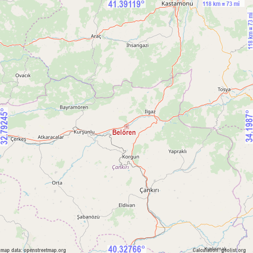
Belören GPS coordinates[2]
40° 51' 41.616" North, 33° 29' 44.052" East
| Map corner | latitude | longitude |
|---|---|---|
| Upper-left | 41.39119°, | 32.79245° |
| Center: | 40.86156°, | 33.49557° |
| Lower-right: | 40.32766°, | 34.1987° |
| Map W x H: | 118.3×118.3 km | = 73.5×73.5mi |
| max Lat: | 42.02683° ⇑14.9% North |
| Belören: | 40.86156° |
| min Lat: | ⇓85.1% South 35.9025° |
| min Long | Belören | max Long |
| 25.90902° | 33.49557° | 44.60099° |
| W 39.6%⇐ | ⇒60.4% E |
Elevation
Elevation of Belören is 935 m = 3068 ft, and this is 217.6 m = 714 ft above average elevation for this country.
| Max E: |
2682 m = 8799 ft | 36.5% |
| Belören | 935 m 3068 ft | |
| Avg. | 717.4 m = 2354 ft | |
Min E: |
0 m = 0 ft | 63.5% |
See also: Turkey elevation on elevation.city.
Geographical zone
Belören is located in North temperate zone (between Tropic of Cancer and the Arctic Circle). Distance of this Northern Tropic circle is 1937.5 km =1203.9 mi to South.| Distance of | km | miles | from Belören |
|---|---|---|---|
| North Pole | 5463.7 | 3395 | to North |
| Arctic Circle | 2857.8 | 1775.8 | to North |
| Tropic Cancer | 1937.5 | 1203.9 | to South |
| Equator | 4543.4 | 2823.1 | to South |


Nearby cities:
15 places around Belören: (largest is in red/bold)
• Akkaya
39.8 km =24.7 mi,  358°
358°
• Araç
44.6 km =27.7 mi,  341°
341°
• Atkaracalar
35.7 km =22.2 mi,  261°
261°
• Bayramören
26.2 km =16.3 mi,  290°
290°
• Boyalı
24.4 km =15.2 mi,  318°
318°
• Eldivan
36.9 km =22.9 mi,  179°
179°
• Ilgaz
13 km =8.1 mi,  57°
57°
• Khanjarah
30.8 km =19.1 mi,  160°
160°
• Korgun
14.2 km =8.8 mi,  172°
172°
• Kurşunlu
19.9 km =12.4 mi, 263°
• Kuzyaka
45.4 km =28.2 mi,  24°
24°
• Orta
41.9 km =26 mi,  230°
230°
• Yapraklı
26.4 km =16.4 mi,  115°
115°
• İhsangazi
38.4 km =23.9 mi,  7°
7°
• İkizören
37.9 km =23.5 mi, 120°
Sources, notices
• [Note1] Compared only with cities in Turkey existing in our database
• [Src1] Map data: © OpenStreetMap contributors (CC-BY-SA)
• [Src2] Other city data from geonames.org with taken over terms of usage.
• [Src3] Geographical zone / Annual Mean Temperature by Robert A. Rohde @ Wikipedia
