Boyalı geodata
Boyalı (Kastamonu) is a seat of a third-order administrative division; located in Turkey in Europe/Istanbul (GMT+3) time zone. In our database, there are 1323 cities with bigger population. Compared to other cities in Turkey, 90.1% of cities are located further ↓South; 61.2% of cities are located further →East and 50.8% of cities have higher elevation than Boyalı. Note1


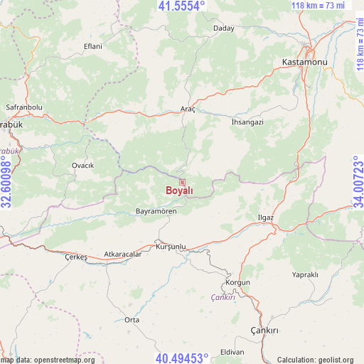
Boyalı GPS coordinates[2]
41° 1' 37.56" North, 33° 18' 14.76" East
| Map corner | latitude | longitude |
|---|---|---|
| Upper-left | 41.5554°, | 32.60098° |
| Center: | 41.0271°, | 33.3041° |
| Lower-right: | 40.49453°, | 34.00723° |
| Map W x H: | 118×118 km | = 73.3×73.3mi |
| max Lat: | 42.02683° ⇑9.9% North |
| Boyalı: | 41.0271° |
| min Lat: | ⇓90.1% South 35.9025° |
| min Long | Boyalı | max Long |
| 25.90902° | 33.3041° | 44.60099° |
| W 38.8%⇐ | ⇒61.2% E |
Elevation
Elevation of Boyalı is 676 m = 2218 ft, and this is 41.4 m = 136 ft below average elevation for this country.
| Max E: |
2682 m = 8799 ft | 50.8% |
| Avg. | 717.4 m = 2354 ft | |
| Boyalı | 676 m = 2218 ft | |
Min E: |
0 m = 0 ft | 49.2% |
See also: Turkey elevation on elevation.city.
Geographical zone
Boyalı is located in North temperate zone (between Tropic of Cancer and the Arctic Circle). Distance of this Northern Tropic circle is 1955.9 km =1215.3 mi to South.| Distance of | km | miles | from Boyalı |
|---|---|---|---|
| North Pole | 5445.3 | 3383.6 | to North |
| Arctic Circle | 2839.4 | 1764.3 | to North |
| Tropic Cancer | 1955.9 | 1215.3 | to South |
| Equator | 4561.8 | 2834.6 | to South |


Nearby cities:
15 places around Boyalı: (largest is in red/bold)
• Akkaya
26.2 km =16.3 mi,  35°
35°
• Araç
24 km =14.9 mi,  4°
4°
• Atkaracalar
30.3 km =18.8 mi,  219°
219°
• Bayramören
12.6 km =7.8 mi, 222°
• Belören
24.4 km =15.2 mi,  138°
138°
• Ilgaz
29.3 km =18.2 mi,  112°
112°
• Korgun
37.2 km =23.1 mi,  150°
150°
• Kurşunlu
21 km =13 mi,  190°
190°
• Kuzyaka
41.8 km =26 mi,  56°
56°
• Orta
47.7 km =29.6 mi,  200°
200°
• Ovacık
32.7 km =20.3 mi,  279°
279°
• Yapraklı
49.8 km =30.9 mi,  126°
126°
• Çerkeş
42 km =26.1 mi,  235°
235°
• İhsangazi
28.8 km =17.9 mi,  46°
46°
• İğdir
26.2 km =16.3 mi,  327°
327°
Sources, notices
• [Note1] Compared only with cities in Turkey existing in our database
• [Src1] Map data: © OpenStreetMap contributors (CC-BY-SA)
• [Src2] Other city data from geonames.org with taken over terms of usage.
• [Src3] Geographical zone / Annual Mean Temperature by Robert A. Rohde @ Wikipedia
