İğdir geodata
İğdir (Kastamonu) is a seat of a third-order administrative division; located in Turkey in Europe/Istanbul (GMT+3) time zone. In our database, there are 1323 cities with bigger population. Compared to other cities in Turkey, 94.7% of cities are located further ↓South; 61.7% of cities are located further →East and 57.2% of cities have higher elevation than İğdir. Note1


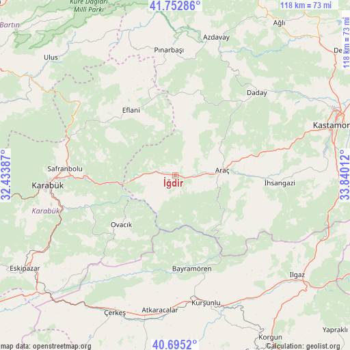
İğdir GPS coordinates[2]
41° 13' 34.212" North, 33° 8' 13.164" East
| Map corner | latitude | longitude |
|---|---|---|
| Upper-left | 41.75286°, | 32.43387° |
| Center: | 41.22617°, | 33.13699° |
| Lower-right: | 40.6952°, | 33.84012° |
| Map W x H: | 117.6×117.6 km | = 73.1×73.1mi |
| max Lat: | 42.02683° ⇑5.3% North |
| İğdir: | 41.22617° |
| min Lat: | ⇓94.7% South 35.9025° |
| min Long | İğdir | max Long |
| 25.90902° | 33.13699° | 44.60099° |
| W 38.3%⇐ | ⇒61.7% E |
Elevation
Elevation of İğdir is 551 m = 1808 ft, and this is 166.4 m = 546 ft below average elevation for this country.
| Max E: |
2682 m = 8799 ft | 57.2% |
| Avg. | 717.4 m = 2354 ft | |
| İğdir | 551 m = 1808 ft | |
Min E: |
0 m = 0 ft | 42.8% |
See also: Turkey elevation on elevation.city.
Geographical zone
İğdir is located in North temperate zone (between Tropic of Cancer and the Arctic Circle). Distance of this Northern Tropic circle is 1978 km =1229.1 mi to South.| Distance of | km | miles | from İğdir |
|---|---|---|---|
| North Pole | 5423.1 | 3369.8 | to North |
| Arctic Circle | 2817.3 | 1750.6 | to North |
| Tropic Cancer | 1978 | 1229.1 | to South |
| Equator | 4583.9 | 2848.3 | to South |


Nearby cities:
15 places around İğdir: (largest is in red/bold)
• Akkaya
29.1 km =18.1 mi,  91°
91°
• Araç
16 km =9.9 mi,  83°
83°
• Atkaracalar
45.9 km =28.5 mi,  186°
186°
• Azdavay
48.3 km =30 mi,  16°
16°
• Bayramören
31.9 km =19.8 mi,  170°
170°
• Boyalı
26.2 km =16.3 mi,  147°
147°
• Daday
39.3 km =24.4 mi,  44°
44°
• Eflani
26.5 km =16.5 mi,  325°
325°
• Karabük
42.7 km =26.5 mi,  266°
266°
• Kurşunlu
44.1 km =27.4 mi, 166°
• Ovacuma
40.4 km =25.1 mi,  307°
307°
• Ovacık
24.6 km =15.3 mi,  227°
227°
• Pınarbaşı
42.1 km =26.2 mi,  357°
357°
• Safranbolu
37.1 km =23.1 mi, 274°
• İhsangazi
35 km =21.7 mi, 93°
Sources, notices
• [Note1] Compared only with cities in Turkey existing in our database
• [Src1] Map data: © OpenStreetMap contributors (CC-BY-SA)
• [Src2] Other city data from geonames.org with taken over terms of usage.
• [Src3] Geographical zone / Annual Mean Temperature by Robert A. Rohde @ Wikipedia
