Beyçayırı geodata
Beyçayırı (Canakkale) is a seat of a third-order administrative division; located in Turkey in Europe/Istanbul (GMT+3) time zone. In our database, there are 1323 cities with bigger population. Compared to other cities in Turkey, 73.6% of cities are located further ↓South; 97.3% of cities are located further →East and 62.6% of cities have higher elevation than Beyçayırı. Note1


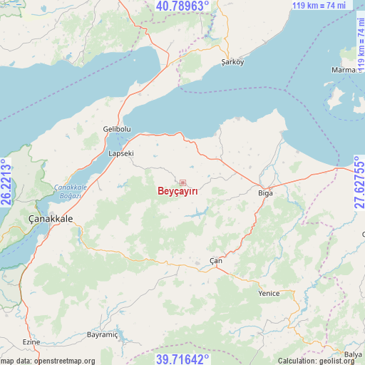
Beyçayırı GPS coordinates[2]
40° 15' 18.54" North, 26° 55' 27.912" East
| Map corner | latitude | longitude |
|---|---|---|
| Upper-left | 40.78963°, | 26.2213° |
| Center: | 40.25515°, | 26.92442° |
| Lower-right: | 39.71642°, | 27.62755° |
| Map W x H: | 119.3×119.3 km | = 74.1×74.1mi |
| max Lat: | 42.02683° ⇑26.4% North |
| Beyçayırı: | 40.25515° |
| min Lat: | ⇓73.6% South 35.9025° |
| min Long | Beyçayırı | max Long |
| 25.90902° | 26.92442° | 44.60099° |
| W 2.7%⇐ | ⇒97.3% E |
Elevation
Elevation of Beyçayırı is 462 m = 1516 ft, and this is 255.4 m = 838 ft below average elevation for this country.
| Max E: |
2682 m = 8799 ft | 62.6% |
| Avg. | 717.4 m = 2354 ft | |
| Beyçayırı | 462 m = 1516 ft | |
Min E: |
0 m = 0 ft | 37.4% |
See also: Turkey elevation on elevation.city.
Geographical zone
Beyçayırı is located in North temperate zone (between Tropic of Cancer and the Arctic Circle). Distance of this Northern Tropic circle is 1870 km =1162 mi to South.| Distance of | km | miles | from Beyçayırı |
|---|---|---|---|
| North Pole | 5531.1 | 3436.9 | to North |
| Arctic Circle | 2925.2 | 1817.6 | to North |
| Tropic Cancer | 1870 | 1162 | to South |
| Equator | 4476 | 2781.3 | to South |


Nearby cities:
15 places around Beyçayırı: (largest is in red/bold)
• Bakacak
14.6 km =9.1 mi,  112°
112°
• Balıklıçeşme
14.7 km =9.1 mi,  65°
65°
• Biga
27.1 km =16.8 mi,  96°
96°
• Bolayır
32.2 km =20 mi,  333°
333°
• Dimetoka
30.5 km =19 mi,  84°
84°
• Etili
30.1 km =18.7 mi,  184°
184°
• Gelibolu
27.6 km =17.1 mi,  308°
308°
• Gündoğdu
14.3 km =8.9 mi,  86°
86°
• Karabiga
36.2 km =22.5 mi,  62°
62°
• Kirazlı
30.4 km =18.9 mi,  218°
218°
• Lapseki
22.5 km =14 mi,  296°
296°
• Sinekçi
41 km =25.5 mi, 87°
• Umurbey
27.1 km =16.8 mi,  264°
264°
• Çan
27 km =16.8 mi,  156°
156°
• Şarköy
43.1 km =26.8 mi,  22°
22°
Sources, notices
• [Note1] Compared only with cities in Turkey existing in our database
• [Src1] Map data: © OpenStreetMap contributors (CC-BY-SA)
• [Src2] Other city data from geonames.org with taken over terms of usage.
• [Src3] Geographical zone / Annual Mean Temperature by Robert A. Rohde @ Wikipedia
