Bolayır geodata
Bolayır (Canakkale) is a seat of a third-order administrative division; located in Turkey in Europe/Istanbul (GMT+3) time zone. In our database, there are 1323 cities with bigger population. Compared to other cities in Turkey, 77.8% of cities are located further ↓South; 98.1% of cities are located further →East and 81.5% of cities have higher elevation than Bolayır. Note1


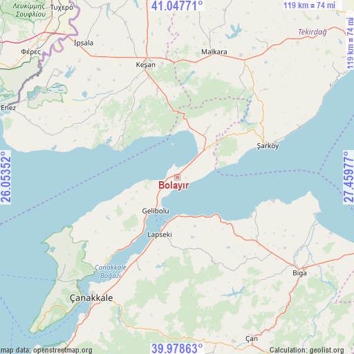
Bolayır GPS coordinates[2]
40° 30' 55.08" North, 26° 45' 23.904" East
| Map corner | latitude | longitude |
|---|---|---|
| Upper-left | 41.04771°, | 26.05352° |
| Center: | 40.5153°, | 26.75664° |
| Lower-right: | 39.97863°, | 27.45977° |
| Map W x H: | 118.9×118.9 km | = 73.9×73.9mi |
| max Lat: | 42.02683° ⇑22.2% North |
| Bolayır: | 40.5153° |
| min Lat: | ⇓77.8% South 35.9025° |
| min Long | Bolayır | max Long |
| 25.90902° | 26.75664° | 44.60099° |
| W 1.9%⇐ | ⇒98.1% E |
Elevation
Elevation of Bolayır is 100 m = 328 ft, and this is 617.4 m = 2026 ft below average elevation for this country.
| Max E: |
2682 m = 8799 ft | 81.5% |
| Avg. | 717.4 m = 2354 ft | |
| Bolayır | 100 m = 328 ft | |
Min E: |
0 m = 0 ft | 18.5% |
See also: Turkey elevation on elevation.city.
Geographical zone
Bolayır is located in North temperate zone (between Tropic of Cancer and the Arctic Circle). Distance of this Northern Tropic circle is 1899 km =1180 mi to South.| Distance of | km | miles | from Bolayır |
|---|---|---|---|
| North Pole | 5502.2 | 3418.9 | to North |
| Arctic Circle | 2896.3 | 1799.7 | to North |
| Tropic Cancer | 1899 | 1180 | to South |
| Equator | 4504.9 | 2799.2 | to South |


Nearby cities:
15 places around Bolayır: (largest is in red/bold)
• Bakacak
44.2 km =27.5 mi,  141°
141°
• Ballı
43.1 km =26.8 mi,  35°
35°
• Balıklıçeşme
35.7 km =22.2 mi,  129°
129°
• Beyçayırı
32.2 km =20 mi,  153°
153°
• Evreşe
19.9 km =12.4 mi,  32°
32°
• Gelibolu
13.7 km =8.5 mi,  211°
211°
• Gündoğdu
39.9 km =24.8 mi, 134°
• Karabiga
47.9 km =29.8 mi,  105°
105°
• Keşan
39.3 km =24.4 mi,  344°
344°
• Lapseki
20 km =12.4 mi,  197°
197°
• Malkara
43.4 km =27 mi,  16°
16°
• Mecidiye
22.9 km =14.2 mi,  306°
306°
• Umurbey
33.8 km =21 mi, 202°
• Çanakkale
49.5 km =30.8 mi,  216°
216°
• Şarköy
32.2 km =20 mi,  70°
70°
Sources, notices
• [Note1] Compared only with cities in Turkey existing in our database
• [Src1] Map data: © OpenStreetMap contributors (CC-BY-SA)
• [Src2] Other city data from geonames.org with taken over terms of usage.
• [Src3] Geographical zone / Annual Mean Temperature by Robert A. Rohde @ Wikipedia
