Gelibolu geodata
Gelibolu (Canakkale) is a seat of a second-order administrative division; located in Turkey in Europe/Istanbul (GMT+3) time zone. With population of 25,178 people, there are 282 cities with bigger population in this country. Compared to other cities in Turkey, 76.3% of cities are located further ↓South; 98.5% of cities are located further →East and 92% of cities have higher elevation than Gelibolu. Note1


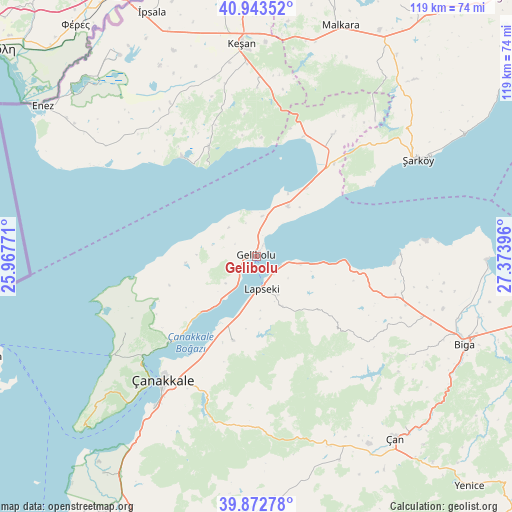
Gelibolu GPS coordinates[2]
40° 24' 37.008" North, 26° 40' 14.988" East
| Map corner | latitude | longitude |
|---|---|---|
| Upper-left | 40.94352°, | 25.96771° |
| Center: | 40.41028°, | 26.67083° |
| Lower-right: | 39.87278°, | 27.37396° |
| Map W x H: | 119.1×119.1 km | = 74×74mi |
| max Lat: | 42.02683° ⇑23.7% North |
| Gelibolu: | 40.41028° |
| min Lat: | ⇓76.3% South 35.9025° |
| min Long | Gelibolu | max Long |
| 25.90902° | 26.67083° | 44.60099° |
| W 1.5%⇐ | ⇒98.5% E |
Elevation
Elevation of Gelibolu is 29 m = 95 ft, and this is 688.4 m = 2259 ft below average elevation for this country.
| Max E: |
2682 m = 8799 ft | 92% |
| Avg. | 717.4 m = 2354 ft | |
| Gelibolu | 29 m = 95 ft | |
Min E: |
0 m = 0 ft | 8% |
See also: Turkey elevation on elevation.city.
Geographical zone
Gelibolu is located in North temperate zone (between Tropic of Cancer and the Arctic Circle). Distance of this Northern Tropic circle is 1887.3 km =1172.7 mi to South.| Distance of | km | miles | from Gelibolu |
|---|---|---|---|
| North Pole | 5513.9 | 3426.2 | to North |
| Arctic Circle | 2908 | 1806.9 | to North |
| Tropic Cancer | 1887.3 | 1172.7 | to South |
| Equator | 4493.2 | 2791.9 | to South |


Nearby cities:
15 places around Gelibolu: (largest is in red/bold)
• Bakacak
41.8 km =26 mi,  123°
123°
• Balıklıçeşme
36.5 km =22.7 mi,  107°
107°
• Beyçayırı
27.6 km =17.1 mi,  128°
128°
• Bolayır
13.7 km =8.5 mi,  31°
31°
• Eceabat
36.6 km =22.7 mi,  226°
226°
• Evreşe
33.7 km =20.9 mi, 32°
• Gündoğdu
39.3 km =24.4 mi, 114°
• Keşan
49.7 km =30.9 mi,  356°
356°
• Kirazlı
41.1 km =25.5 mi,  176°
176°
• Lapseki
7.5 km =4.7 mi,  170°
170°
• Mecidiye
27.7 km =17.2 mi,  336°
336°
• Merkez
37.7 km =23.4 mi,  214°
214°
• Umurbey
20.4 km =12.7 mi,  195°
195°
• Çanakkale
35.8 km =22.2 mi,  217°
217°
• Şarköy
43.9 km =27.3 mi,  58°
58°
In other languages:
- In Spanish: Galípoli
- In Italian: Gallipoli
- In Russian: Гелиболу
- In Chinese: 蓋利博盧
Sources, notices
• [Note1] Compared only with cities in Turkey existing in our database
• [Src1] Map data: © OpenStreetMap contributors (CC-BY-SA)
• [Src2] Other city data from geonames.org with taken over terms of usage.
• [Src3] Geographical zone / Annual Mean Temperature by Robert A. Rohde @ Wikipedia
