Şarköy geodata
Şarköy (Tekirdağ) is a seat of a second-order administrative division; located in Turkey in Europe/Istanbul (GMT+3) time zone. In our database, there are 1323 cities with bigger population. Compared to other cities in Turkey, 79.2% of cities are located further ↓South; 96.3% of cities are located further →East and 95.9% of cities have higher elevation than Şarköy. Note1


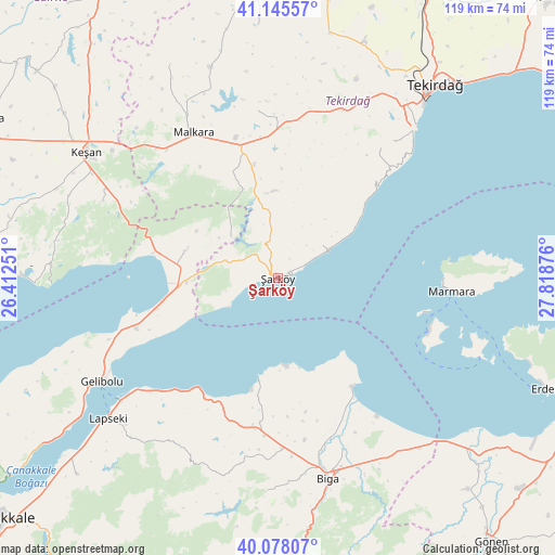
Şarköy GPS coordinates[2]
40° 36' 50.22" North, 27° 6' 56.268" East
| Map corner | latitude | longitude |
|---|---|---|
| Upper-left | 41.14557°, | 26.41251° |
| Center: | 40.61395°, | 27.11563° |
| Lower-right: | 40.07807°, | 27.81876° |
| Map W x H: | 118.7×118.7 km | = 73.8×73.8mi |
| max Lat: | 42.02683° ⇑20.8% North |
| Şarköy: | 40.61395° |
| min Lat: | ⇓79.2% South 35.9025° |
| min Long | Şarköy | max Long |
| 25.90902° | 27.11563° | 44.60099° |
| W 3.7%⇐ | ⇒96.3% E |
Elevation
Elevation of Şarköy is 14 m = 46 ft, and this is 703.4 m = 2308 ft below average elevation for this country.
| Max E: |
2682 m = 8799 ft | 95.9% |
| Avg. | 717.4 m = 2354 ft | |
| Şarköy | 14 m = 46 ft | |
Min E: |
0 m = 0 ft | 4.1% |
See also: Turkey elevation on elevation.city.
Geographical zone
Şarköy is located in North temperate zone (between Tropic of Cancer and the Arctic Circle). Distance of this Northern Tropic circle is 1909.9 km =1186.8 mi to South.| Distance of | km | miles | from Şarköy |
|---|---|---|---|
| North Pole | 5491.2 | 3412.1 | to North |
| Arctic Circle | 2885.3 | 1792.8 | to North |
| Tropic Cancer | 1909.9 | 1186.8 | to South |
| Equator | 4515.8 | 2806 | to South |


Nearby cities:
15 places around Şarköy: (largest is in red/bold)
• Ballı
24.6 km =15.3 mi,  348°
348°
• Balıklıçeşme
33.9 km =21.1 mi,  184°
184°
• Beyçayırı
43.1 km =26.8 mi,  202°
202°
• Biga
44.2 km =27.5 mi,  165°
165°
• Bolayır
32.2 km =20 mi,  250°
250°
• Dimetoka
39.5 km =24.5 mi,  159°
159°
• Evreşe
20.5 km =12.7 mi,  286°
286°
• Gelibolu
43.9 km =27.3 mi,  238°
238°
• Gündoğdu
38.9 km =24.2 mi, 182°
• Karabiga
28.3 km =17.6 mi,  145°
145°
• Kumbağ
41.6 km =25.8 mi,  44°
44°
• Malkara
35.6 km =22.1 mi,  329°
329°
• Marmara
37.3 km =23.2 mi,  94°
94°
• Yürük
36 km =22.4 mi, 353°
• İnecik
38.3 km =23.8 mi,  21°
21°
Sources, notices
• [Note1] Compared only with cities in Turkey existing in our database
• [Src1] Map data: © OpenStreetMap contributors (CC-BY-SA)
• [Src2] Other city data from geonames.org with taken over terms of usage.
• [Src3] Geographical zone / Annual Mean Temperature by Robert A. Rohde @ Wikipedia
