Kurucaşile geodata
Kurucaşile (Bartın) is a seat of a second-order administrative division; located in Turkey in Europe/Istanbul (GMT+3) time zone. With population of 2,066 people, there are 944 cities with bigger population in this country. Compared to other cities in Turkey, 99.2% of cities are located further ↓South; 63.4% of cities are located further →East and 84.7% of cities have higher elevation than Kurucaşile. Note1


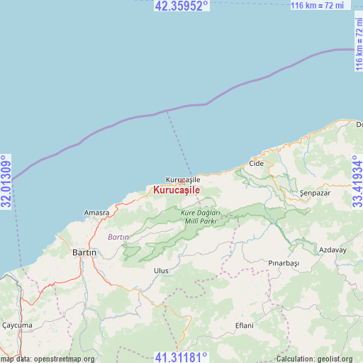
Kurucaşile GPS coordinates[2]
41° 50' 16.116" North, 32° 42' 58.356" East
| Map corner | latitude | longitude |
|---|---|---|
| Upper-left | 42.35952°, | 32.01309° |
| Center: | 41.83781°, | 32.71621° |
| Lower-right: | 41.31181°, | 33.41934° |
| Map W x H: | 116.5×116.5 km | = 72.4×72.4mi |
| max Lat: | 42.02683° ⇑0.8% North |
| Kurucaşile: | 41.83781° |
| min Lat: | ⇓99.2% South 35.9025° |
| min Long | Kurucaşile | max Long |
| 25.90902° | 32.71621° | 44.60099° |
| W 36.6%⇐ | ⇒63.4% E |
Elevation
Elevation of Kurucaşile is 73 m = 240 ft, and this is 644.4 m = 2114 ft below average elevation for this country.
| Max E: |
2682 m = 8799 ft | 84.7% |
| Avg. | 717.4 m = 2354 ft | |
| Kurucaşile | 73 m = 240 ft | |
Min E: |
0 m = 0 ft | 15.3% |
See also: Turkey elevation on elevation.city.
Geographical zone
Kurucaşile is located in North temperate zone (between Tropic of Cancer and the Arctic Circle). Distance of this Northern Tropic circle is 2046 km =1271.3 mi to South.| Distance of | km | miles | from Kurucaşile |
|---|---|---|---|
| North Pole | 5355.1 | 3327.5 | to North |
| Arctic Circle | 2749.2 | 1708.3 | to North |
| Tropic Cancer | 2046 | 1271.3 | to South |
| Equator | 4651.9 | 2890.6 | to South |


Nearby cities:
15 places around Kurucaşile: (largest is in red/bold)
• Amasra
29.2 km =18.1 mi,  249°
249°
• Arıt
18.4 km =11.4 mi,  204°
204°
• Azdavay
53.1 km =33 mi,  114°
114°
• Bartın
38.6 km =24 mi,  234°
234°
• Cide
24.6 km =15.3 mi,  75°
75°
• Doğanyurt
64.3 km =40 mi,  73°
73°
• Eflani
50.3 km =31.3 mi,  156°
156°
• Kozcağız
50.6 km =31.4 mi,  218°
218°
• Kumluca
48.1 km =29.9 mi,  205°
205°
• Ovacuma
43.4 km =27 mi,  175°
175°
• Pınarbaşı
41.8 km =26 mi,  128°
128°
• Safranbolu
65.3 km =40.6 mi, 181°
• Saltukova
62.4 km =38.8 mi,  235°
235°
• Ulus
28.9 km =18 mi,  192°
192°
• Şenpazar
42.8 km =26.6 mi,  94°
94°
Sources, notices
• [Note1] Compared only with cities in Turkey existing in our database
• [Src1] Map data: © OpenStreetMap contributors (CC-BY-SA)
• [Src2] Other city data from geonames.org with taken over terms of usage.
• [Src3] Geographical zone / Annual Mean Temperature by Robert A. Rohde @ Wikipedia
