Arıt geodata
Arıt (Bartın) is a seat of a third-order administrative division; located in Turkey in Europe/Istanbul (GMT+3) time zone. In our database, there are 1323 cities with bigger population. Compared to other cities in Turkey, 98.7% of cities are located further ↓South; 63.9% of cities are located further →East and 68% of cities have higher elevation than Arıt. Note1


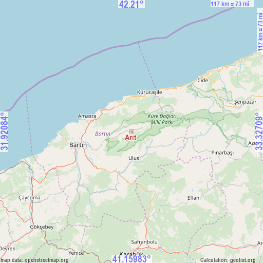
Arıt GPS coordinates[2]
41° 41' 13.416" North, 32° 37' 26.256" East
| Map corner | latitude | longitude |
|---|---|---|
| Upper-left | 42.21°, | 31.92084° |
| Center: | 41.68706°, | 32.62396° |
| Lower-right: | 41.15983°, | 33.32709° |
| Map W x H: | 116.8×116.8 km | = 72.6×72.6mi |
| max Lat: | 42.02683° ⇑1.3% North |
| Arıt: | 41.68706° |
| min Lat: | ⇓98.7% South 35.9025° |
| min Long | Arıt | max Long |
| 25.90902° | 32.62396° | 44.60099° |
| W 36.1%⇐ | ⇒63.9% E |
Elevation
Elevation of Arıt is 360 m = 1181 ft, and this is 357.4 m = 1173 ft below average elevation for this country.
| Max E: |
2682 m = 8799 ft | 68% |
| Avg. | 717.4 m = 2354 ft | |
| Arıt | 360 m = 1181 ft | |
Min E: |
0 m = 0 ft | 32% |
See also: Turkey elevation on elevation.city.
Geographical zone
Arıt is located in North temperate zone (between Tropic of Cancer and the Arctic Circle). Distance of this Northern Tropic circle is 2029.2 km =1260.9 mi to South.| Distance of | km | miles | from Arıt |
|---|---|---|---|
| North Pole | 5371.9 | 3337.9 | to North |
| Arctic Circle | 2766 | 1718.7 | to North |
| Tropic Cancer | 2029.2 | 1260.9 | to South |
| Equator | 4635.2 | 2880.2 | to South |


Nearby cities:
15 places around Arıt: (largest is in red/bold)
• Amasra
20.8 km =12.9 mi,  288°
288°
• Bartın
24.5 km =15.2 mi,  256°
256°
• Cide
38.9 km =24.2 mi,  54°
54°
• Eflani
40.4 km =25.1 mi,  136°
136°
• Filyos
52 km =32.3 mi,  253°
253°
• Kozcağız
33.1 km =20.6 mi,  226°
226°
• Kumluca
29.7 km =18.5 mi,  206°
206°
• Kurucaşile
18.4 km =11.4 mi,  24°
24°
• Ovacuma
28.6 km =17.8 mi,  157°
157°
• Perşembe
48.8 km =30.3 mi, 232°
• Pınarbaşı
41.5 km =25.8 mi,  102°
102°
• Safranbolu
48.9 km =30.4 mi,  173°
173°
• Saltukova
47.6 km =29.6 mi, 247°
• Ulus
11.5 km =7.1 mi, 172°
• Şenpazar
52.2 km =32.4 mi,  74°
74°
Sources, notices
• [Note1] Compared only with cities in Turkey existing in our database
• [Src1] Map data: © OpenStreetMap contributors (CC-BY-SA)
• [Src2] Other city data from geonames.org with taken over terms of usage.
• [Src3] Geographical zone / Annual Mean Temperature by Robert A. Rohde @ Wikipedia
