Vwawa geodata
Vwawa (Songwe) is a seat of a first-order administrative division; located in Tanzania in Africa/Dar_es_Salaam (GMT+3) time zone. With population of 40,145 people, there are 33 cities with bigger population in this country. Compared to other cities in Tanzania, 82.5% of cities are located further ↑North; 80.1% of cities are located further →East and 73.8% of cities have lower elevation than Vwawa. Note1


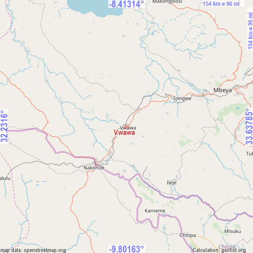
Vwawa GPS coordinates[2]
9° 6' 29.016" South, 32° 56' 4.992" East
| Map corner | latitude | longitude |
|---|---|---|
| Upper-left | -8.41314°, | 32.2316° |
| Center: | -9.10806°, | 32.93472° |
| Lower-right: | -9.80163°, | 33.63785° |
| Map W x H: | 154.4×154.4 km | = 95.9×95.9mi |
| max Lat: | -1.14389° ⇑82.5% North |
| Vwawa: | -9.10806° |
| min Lat: | ⇓17.5% South -11.36667° |
| min Long | Vwawa | max Long |
| 29.62667° | 32.93472° | 40.33333° |
| W 19.9%⇐ | ⇒80.1% E |
Elevation
Elevation of Vwawa is 1331 m = 4367 ft, and this is 388.2 m = 1274 ft above average elevation for this country.
| Max E: |
2377 m = 7799 ft | 26.2% |
| Vwawa | 1331 m 4367 ft | |
| Avg. | 942.8 m = 3093 ft | |
Min E: |
0 m = 0 ft | 73.8% |
See also: Vwawa elevation on elevation.city.
Geographical zone
Vwawa is located in South Torrid zone (between Equator and Tropic of Capricorn). Distance of Equator is 1012.7 km =629.3 mi to North.| Distance of | km | miles | from Vwawa |
|---|---|---|---|
| Equator | 1012.7 | 629.3 | to North |
| Tropic Capricorn | 1593.2 | 990 | to South |
| Antarctic Circle | 6388.5 | 3969.6 | to South |
| South Pole | 8994.3 | 5588.8 | to South |


Nearby cities:
15 places around Vwawa: (largest is in red/bold)
• Igurusi
104.5 km =64.9 mi,  74°
74°
• Ilembo
51.7 km =32.1 mi,  107°
107°
• Ipinda
113.8 km =70.7 mi, 111°
• Itumba
42.4 km =26.3 mi,  139°
139°
• Kandete
95.1 km =59.1 mi,  92°
92°
• Katumba
76.1 km =47.3 mi,  100°
100°
• Kiwira
67 km =41.6 mi, 96°
• Kyela
113.5 km =70.5 mi,  117°
117°
• Masoko
92.9 km =57.7 mi, 105°
• Matamba
114.2 km =71 mi,  83°
83°
• Mbeya
61.1 km =38 mi, 67°
• Mlowo
13.1 km =8.1 mi,  23°
23°
• Tukuyu
80.1 km =49.8 mi, 101°
• Tunduma
28.2 km =17.5 mi,  220°
220°
• Ulenje
84.5 km =52.5 mi, 76°
Sources, notices
• [Note1] Compared only with cities in Tanzania existing in our database
• [Src1] Map data: © OpenStreetMap contributors (CC-BY-SA)
• [Src2] Other city data from geonames.org with taken over terms of usage.
• [Src3] Geographical zone / Annual Mean Temperature by Robert A. Rohde @ Wikipedia
