Masoko geodata
Masoko (Mbeya) is a populated place; located in Tanzania in Africa/Dar_es_Salaam (GMT+3) time zone. With population of 12,720 people, there are 203 cities with bigger population in this country. Compared to other cities in Tanzania, 85% of cities are located further ↑North; 70.3% of cities are located further →East and 61.5% of cities have higher elevation than Masoko. Note1


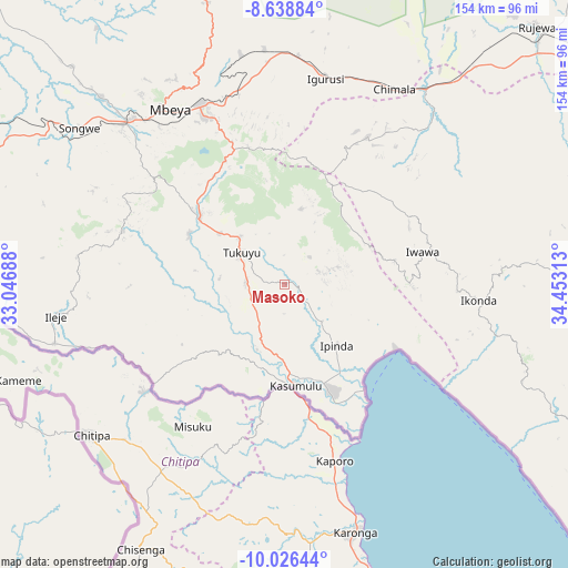
Masoko GPS coordinates[2]
9° 19' 59.988" South, 33° 45' 0" East
| Map corner | latitude | longitude |
|---|---|---|
| Upper-left | -8.63884°, | 33.04688° |
| Center: | -9.33333°, | 33.75° |
| Lower-right: | -10.02644°, | 34.45313° |
| Map W x H: | 154.3×154.3 km | = 95.9×95.9mi |
| max Lat: | -1.14389° ⇑85% North |
| Masoko: | -9.33333° |
| min Lat: | ⇓15% South -11.36667° |
| min Long | Masoko | max Long |
| 29.62667° | 33.75° | 40.33333° |
| W 29.7%⇐ | ⇒70.3% E |
Elevation
Elevation of Masoko is 887 m = 2910 ft, and this is 55.8 m = 183 ft below average elevation for this country.
| Max E: |
2377 m = 7799 ft | 61.5% |
| Avg. | 942.8 m = 3093 ft | |
| Masoko | 887 m = 2910 ft | |
Min E: |
0 m = 0 ft | 38.5% |
See also: Tanzania elevation on elevation.city.
Geographical zone
Masoko is located in South Torrid zone (between Equator and Tropic of Capricorn). Distance of Equator is 1037.8 km =644.9 mi to North.| Distance of | km | miles | from Masoko |
|---|---|---|---|
| Equator | 1037.8 | 644.9 | to North |
| Tropic Capricorn | 1568.1 | 974.4 | to South |
| Antarctic Circle | 6363.4 | 3954 | to South |
| South Pole | 8969.3 | 5573.3 | to South |


Nearby cities:
15 places around Masoko: (largest is in red/bold)
• Chimala
61 km =37.9 mi,  29°
29°
• Igurusi
54.9 km =34.1 mi,  11°
11°
• Ilembo
41.3 km =25.7 mi,  282°
282°
• Ipinda
23.4 km =14.5 mi,  135°
135°
• Itumba
62.6 km =38.9 mi,  263°
263°
• Kandete
21.1 km =13.1 mi,  15°
15°
• Katumba
18.4 km =11.4 mi,  307°
307°
• Kiwira
29 km =18 mi, 307°
• Kyela
29.9 km =18.6 mi,  158°
158°
• Matamba
45.6 km =28.3 mi, 31°
• Mbeya
58.4 km =36.3 mi,  325°
325°
• Mlowo
92 km =57.2 mi,  293°
293°
• Mwaya
32.6 km =20.3 mi, 137°
• Tukuyu
14.4 km =8.9 mi, 310°
• Ulenje
45.1 km =28 mi,  350°
350°
Sources, notices
• [Note1] Compared only with cities in Tanzania existing in our database
• [Src1] Map data: © OpenStreetMap contributors (CC-BY-SA)
• [Src2] Other city data from geonames.org with taken over terms of usage.
• [Src3] Geographical zone / Annual Mean Temperature by Robert A. Rohde @ Wikipedia
