Kandete geodata
Kandete (Mbeya) is a populated place; located in Tanzania in Africa/Dar_es_Salaam (GMT+3) time zone. With population of 10,318 people, there are 235 cities with bigger population in this country. Compared to other cities in Tanzania, 82.9% of cities are located further ↑North; 69.6% of cities are located further →East and 87.8% of cities have lower elevation than Kandete. Note1


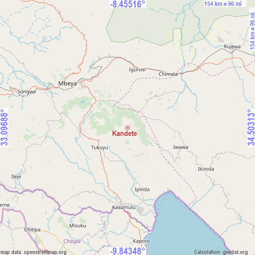
Kandete GPS coordinates[2]
9° 9' 0" South, 33° 48' 0" East
| Map corner | latitude | longitude |
|---|---|---|
| Upper-left | -8.45516°, | 33.09688° |
| Center: | -9.15°, | 33.8° |
| Lower-right: | -9.84348°, | 34.50313° |
| Map W x H: | 154.4×154.4 km | = 95.9×95.9mi |
| max Lat: | -1.14389° ⇑82.9% North |
| Kandete: | -9.15° |
| min Lat: | ⇓17.1% South -11.36667° |
| min Long | Kandete | max Long |
| 29.62667° | 33.8° | 40.33333° |
| W 30.4%⇐ | ⇒69.6% E |
Elevation
Elevation of Kandete is 1578 m = 5177 ft, and this is 635.2 m = 2084 ft above average elevation for this country.
| Max E: |
2377 m = 7799 ft | 12.2% |
| Kandete | 1578 m 5177 ft | |
| Avg. | 942.8 m = 3093 ft | |
Min E: |
0 m = 0 ft | 87.8% |
See also: Tanzania elevation on elevation.city.
Geographical zone
Kandete is located in South Torrid zone (between Equator and Tropic of Capricorn). Distance of Equator is 1017.4 km =632.2 mi to North.| Distance of | km | miles | from Kandete |
|---|---|---|---|
| Equator | 1017.4 | 632.2 | to North |
| Tropic Capricorn | 1588.5 | 987 | to South |
| Antarctic Circle | 6383.8 | 3966.7 | to South |
| South Pole | 8989.7 | 5585.9 | to South |


Nearby cities:
15 places around Kandete: (largest is in red/bold)
• Chimala
40.9 km =25.4 mi,  36°
36°
• Igurusi
33.8 km =21 mi,  9°
9°
• Ilembo
47.1 km =29.3 mi,  256°
256°
• Ipinda
38.7 km =24 mi,  163°
163°
• Itumba
73.2 km =45.5 mi,  247°
247°
• Katumba
22.2 km =13.8 mi, 245°
• Kiwira
28.5 km =17.7 mi, 264°
• Kyela
48.5 km =30.1 mi,  173°
173°
• Masoko
21.1 km =13.1 mi,  195°
195°
• Matamba
26 km =16.2 mi, 44°
• Mbeya
47.4 km =29.5 mi,  305°
305°
• Mwaya
47.4 km =29.5 mi, 159°
• Rujewa
81.3 km =50.5 mi,  52°
52°
• Tukuyu
19.9 km =12.4 mi,  235°
235°
• Ulenje
27.3 km =17 mi,  331°
331°
Sources, notices
• [Note1] Compared only with cities in Tanzania existing in our database
• [Src1] Map data: © OpenStreetMap contributors (CC-BY-SA)
• [Src2] Other city data from geonames.org with taken over terms of usage.
• [Src3] Geographical zone / Annual Mean Temperature by Robert A. Rohde @ Wikipedia
