Ipinda geodata
Ipinda (Mbeya) is a populated place; located in Tanzania in Africa/Dar_es_Salaam (GMT+3) time zone. With population of 17,775 people, there are 153 cities with bigger population in this country. Compared to other cities in Tanzania, 86% of cities are located further ↑North; 67.1% of cities are located further →East and 70.6% of cities have higher elevation than Ipinda. Note1


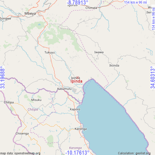
Ipinda GPS coordinates[2]
9° 28' 59.988" South, 33° 54' 0" East
| Map corner | latitude | longitude |
|---|---|---|
| Upper-left | -8.78913°, | 33.19688° |
| Center: | -9.48333°, | 33.9° |
| Lower-right: | -10.17613°, | 34.60313° |
| Map W x H: | 154.2×154.2 km | = 95.8×95.8mi |
| max Lat: | -1.14389° ⇑86% North |
| Ipinda: | -9.48333° |
| min Lat: | ⇓14% South -11.36667° |
| min Long | Ipinda | max Long |
| 29.62667° | 33.9° | 40.33333° |
| W 32.9%⇐ | ⇒67.1% E |
Elevation
Elevation of Ipinda is 490 m = 1608 ft, and this is 452.8 m = 1486 ft below average elevation for this country.
| Max E: |
2377 m = 7799 ft | 70.6% |
| Avg. | 942.8 m = 3093 ft | |
| Ipinda | 490 m = 1608 ft | |
Min E: |
0 m = 0 ft | 29.4% |
See also: Tanzania elevation on elevation.city.
Geographical zone
Ipinda is located in South Torrid zone (between Equator and Tropic of Capricorn). Distance of Equator is 1054.4 km =655.2 mi to North.| Distance of | km | miles | from Ipinda |
|---|---|---|---|
| Equator | 1054.4 | 655.2 | to North |
| Tropic Capricorn | 1551.5 | 964.1 | to South |
| Antarctic Circle | 6346.7 | 3943.7 | to South |
| South Pole | 8952.6 | 5562.9 | to South |


Nearby cities:
15 places around Ipinda: (largest is in red/bold)
• Chimala
71 km =44.1 mi,  11°
11°
• Igurusi
70.6 km =43.9 mi,  355°
355°
• Ilembo
62.3 km =38.7 mi,  294°
294°
• Itumba
79.2 km =49.2 mi,  276°
276°
• Kandete
38.7 km =24 mi,  343°
343°
• Katumba
41.7 km =25.9 mi,  311°
311°
• Kiwira
52.3 km =32.5 mi, 311°
• Kyela
12.4 km =7.7 mi,  206°
206°
• Masoko
23.4 km =14.5 mi,  315°
315°
• Matamba
56.1 km =34.9 mi, 7°
• Mbeya
81.5 km =50.6 mi, 322°
• Mlangali
75.4 km =46.9 mi,  116°
116°
• Mwaya
9.2 km =5.7 mi,  143°
143°
• Tukuyu
37.8 km =23.5 mi, 313°
• Ulenje
65.6 km =40.8 mi, 338°
Sources, notices
• [Note1] Compared only with cities in Tanzania existing in our database
• [Src1] Map data: © OpenStreetMap contributors (CC-BY-SA)
• [Src2] Other city data from geonames.org with taken over terms of usage.
• [Src3] Geographical zone / Annual Mean Temperature by Robert A. Rohde @ Wikipedia
