Kyela geodata
Kyela (Mbeya) is a populated place; located in Tanzania in Africa/Dar_es_Salaam (GMT+3) time zone. With population of 30,684 people, there are 60 cities with bigger population in this country. Compared to other cities in Tanzania, 86.7% of cities are located further ↑North; 68.9% of cities are located further →East and 69.6% of cities have higher elevation than Kyela. Note1


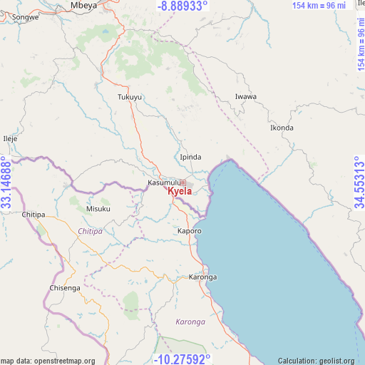
Kyela GPS coordinates[2]
9° 34' 59.988" South, 33° 51' 0" East
| Map corner | latitude | longitude |
|---|---|---|
| Upper-left | -8.88933°, | 33.14688° |
| Center: | -9.58333°, | 33.85° |
| Lower-right: | -10.27592°, | 34.55313° |
| Map W x H: | 154.2×154.2 km | = 95.8×95.8mi |
| max Lat: | -1.14389° ⇑86.7% North |
| Kyela: | -9.58333° |
| min Lat: | ⇓13.3% South -11.36667° |
| min Long | Kyela | max Long |
| 29.62667° | 33.85° | 40.33333° |
| W 31.1%⇐ | ⇒68.9% E |
Elevation
Elevation of Kyela is 498 m = 1634 ft, and this is 444.8 m = 1459 ft below average elevation for this country.
| Max E: |
2377 m = 7799 ft | 69.6% |
| Avg. | 942.8 m = 3093 ft | |
| Kyela | 498 m = 1634 ft | |
Min E: |
0 m = 0 ft | 30.4% |
See also: Tanzania elevation on elevation.city.
Geographical zone
Kyela is located in South Torrid zone (between Equator and Tropic of Capricorn). Distance of Equator is 1065.6 km =662.1 mi to North.| Distance of | km | miles | from Kyela |
|---|---|---|---|
| Equator | 1065.6 | 662.1 | to North |
| Tropic Capricorn | 1540.4 | 957.2 | to South |
| Antarctic Circle | 6335.6 | 3936.8 | to South |
| South Pole | 8941.5 | 5556 | to South |


Nearby cities:
15 places around Kyela: (largest is in red/bold)
• Chimala
83.1 km =51.6 mi,  13°
13°
• Igurusi
81.5 km =50.6 mi,  0°
0°
• Ilembo
63.2 km =39.3 mi,  305°
305°
• Ipinda
12.4 km =7.7 mi,  26°
26°
• Itumba
75.9 km =47.2 mi,  285°
285°
• Kandete
48.5 km =30.1 mi,  353°
353°
• Katumba
46.6 km =29 mi,  326°
326°
• Kiwira
56.8 km =35.3 mi,  323°
323°
• Masoko
29.9 km =18.6 mi,  338°
338°
• Matamba
67.9 km =42.2 mi, 10°
• Mbeya
87.7 km =54.5 mi, 329°
• Mlangali
76.4 km =47.5 mi,  106°
106°
• Mwaya
11.6 km =7.2 mi,  71°
71°
• Tukuyu
43.1 km =26.8 mi, 329°
• Ulenje
74.6 km =46.4 mi, 345°
Sources, notices
• [Note1] Compared only with cities in Tanzania existing in our database
• [Src1] Map data: © OpenStreetMap contributors (CC-BY-SA)
• [Src2] Other city data from geonames.org with taken over terms of usage.
• [Src3] Geographical zone / Annual Mean Temperature by Robert A. Rohde @ Wikipedia
