Mlowo geodata
Mlowo (Songwe) is a populated place; located in Tanzania in Africa/Dar_es_Salaam (GMT+3) time zone. With population of 18,737 people, there are 143 cities with bigger population in this country. Compared to other cities in Tanzania, 81.8% of cities are located further ↑North; 79.7% of cities are located further →East and 89.2% of cities have lower elevation than Mlowo. Note1


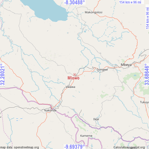
Mlowo GPS coordinates[2]
9° 0' 0" South, 32° 58' 59.988" East
| Map corner | latitude | longitude |
|---|---|---|
| Upper-left | -8.30488°, | 32.28021° |
| Center: | -9°, | 32.98333° |
| Lower-right: | -9.69379°, | 33.68646° |
| Map W x H: | 154.4×154.4 km | = 95.9×95.9mi |
| max Lat: | -1.14389° ⇑81.8% North |
| Mlowo: | -9° |
| min Lat: | ⇓18.2% South -11.36667° |
| min Long | Mlowo | max Long |
| 29.62667° | 32.98333° | 40.33333° |
| W 20.3%⇐ | ⇒79.7% E |
Elevation
Elevation of Mlowo is 1591 m = 5220 ft, and this is 648.2 m = 2127 ft above average elevation for this country.
| Max E: |
2377 m = 7799 ft | 10.8% |
| Mlowo | 1591 m 5220 ft | |
| Avg. | 942.8 m = 3093 ft | |
Min E: |
0 m = 0 ft | 89.2% |
See also: Tanzania elevation on elevation.city.
Geographical zone
Mlowo is located in South Torrid zone (between Equator and Tropic of Capricorn). Distance of Equator is 1000.7 km =621.8 mi to North.| Distance of | km | miles | from Mlowo |
|---|---|---|---|
| Equator | 1000.7 | 621.8 | to North |
| Tropic Capricorn | 1605.2 | 997.4 | to South |
| Antarctic Circle | 6400.5 | 3977.1 | to South |
| South Pole | 9006.4 | 5596.3 | to South |


Nearby cities:
15 places around Mlowo: (largest is in red/bold)
• Igurusi
96.6 km =60 mi,  80°
80°
• Ilembo
52 km =32.3 mi,  122°
122°
• Ipinda
114.1 km =70.9 mi, 118°
• Itumba
49.6 km =30.8 mi,  153°
153°
• Kandete
91.2 km =56.7 mi,  100°
100°
• Katumba
74.2 km =46.1 mi,  110°
110°
• Kiwira
64.2 km =39.9 mi, 107°
• Laela
113.3 km =70.4 mi,  295°
295°
• Masoko
92 km =57.2 mi, 113°
• Matamba
108 km =67.1 mi,  89°
89°
• Mbeya
52.4 km =32.6 mi, 77°
• Tukuyu
78.3 km =48.7 mi, 110°
• Tunduma
41 km =25.5 mi,  215°
215°
• Ulenje
77.2 km =48 mi, 84°
• Vwawa
13.1 km =8.1 mi,  203°
203°
Sources, notices
• [Note1] Compared only with cities in Tanzania existing in our database
• [Src1] Map data: © OpenStreetMap contributors (CC-BY-SA)
• [Src2] Other city data from geonames.org with taken over terms of usage.
• [Src3] Geographical zone / Annual Mean Temperature by Robert A. Rohde @ Wikipedia
