Kasamwa geodata
Kasamwa (Geita) is a populated place; located in Tanzania in Africa/Dar_es_Salaam (GMT+3) time zone. With population of 27,681 people, there are 73 cities with bigger population in this country. Compared to other cities in Tanzania, 86% of cities are located further ↓South; 84.6% of cities are located further →East and 62.2% of cities have lower elevation than Kasamwa. Note1


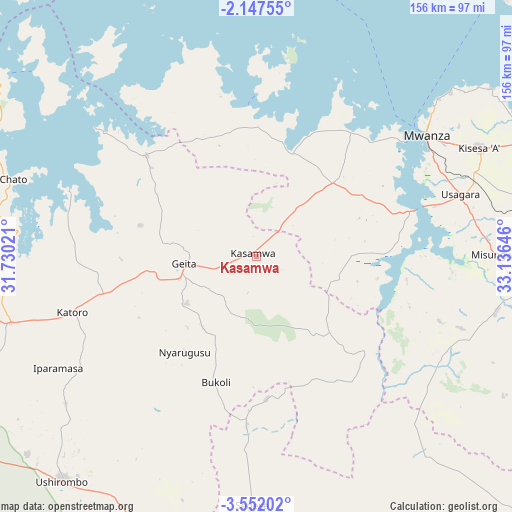
Kasamwa GPS coordinates[2]
2° 51' 0" South, 32° 25' 59.988" East
| Map corner | latitude | longitude |
|---|---|---|
| Upper-left | -2.14755°, | 31.73021° |
| Center: | -2.85°, | 32.43333° |
| Lower-right: | -3.55202°, | 33.13646° |
| Map W x H: | 156.2×156.2 km | = 97.1×97.1mi |
| max Lat: | -1.14389° ⇑14% North |
| Kasamwa: | -2.85° |
| min Lat: | ⇓86% South -11.36667° |
| min Long | Kasamwa | max Long |
| 29.62667° | 32.43333° | 40.33333° |
| W 15.4%⇐ | ⇒84.6% E |
Elevation
Elevation of Kasamwa is 1199 m = 3934 ft, and this is 256.2 m = 841 ft above average elevation for this country.
| Max E: |
2377 m = 7799 ft | 37.8% |
| Kasamwa | 1199 m 3934 ft | |
| Avg. | 942.8 m = 3093 ft | |
Min E: |
0 m = 0 ft | 62.2% |
See also: Tanzania elevation on elevation.city.
Geographical zone
Kasamwa is located in South Torrid zone (between Equator and Tropic of Capricorn). Distance of Equator is 316.9 km =196.9 mi to North.| Distance of | km | miles | from Kasamwa |
|---|---|---|---|
| Equator | 316.9 | 196.9 | to North |
| Tropic Capricorn | 2289 | 1422.3 | to South |
| Antarctic Circle | 7084.3 | 4402 | to South |
| South Pole | 9690.2 | 6021.2 | to South |


Nearby cities:
15 places around Kasamwa: (largest is in red/bold)
• Buseresere
65 km =40.4 mi,  252°
252°
• Chato
77.7 km =48.3 mi,  287°
287°
• Geita
22.4 km =13.9 mi,  263°
263°
• Katoro
62.6 km =38.9 mi, 252°
• Kihangara
106 km =65.9 mi,  73°
73°
• Masumbwe
91.4 km =56.8 mi,  197°
197°
• Mhango
66.8 km =41.5 mi,  136°
136°
• Misasi
74.1 km =46 mi,  103°
103°
• Misungwi
72.2 km =44.9 mi,  90°
90°
• Mwanza
63.7 km =39.6 mi,  54°
54°
• Nansio
105.1 km =65.3 mi,  40°
40°
• Ngudu
100.8 km =62.6 mi, 97°
• Nyanguge
91.5 km =56.9 mi, 68°
• Usagara
65.6 km =40.8 mi, 73°
• Ushirombo
88.4 km =54.9 mi,  216°
216°
Sources, notices
• [Note1] Compared only with cities in Tanzania existing in our database
• [Src1] Map data: © OpenStreetMap contributors (CC-BY-SA)
• [Src2] Other city data from geonames.org with taken over terms of usage.
• [Src3] Geographical zone / Annual Mean Temperature by Robert A. Rohde @ Wikipedia
