Mhango geodata
Mhango (Shinyanga) is a populated place; located in Tanzania in Africa/Dar_es_Salaam (GMT+3) time zone. With population of 21,553 people, there are 114 cities with bigger population in this country. Compared to other cities in Tanzania, 80.8% of cities are located further ↓South; 82.2% of cities are located further →East and 64.7% of cities have lower elevation than Mhango. Note1


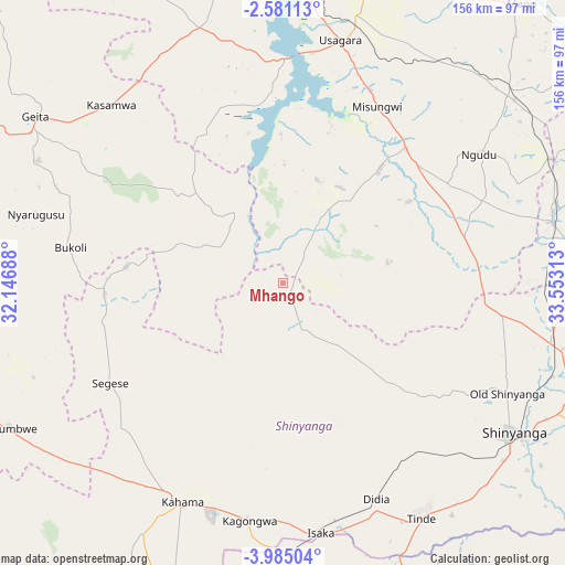
Mhango GPS coordinates[2]
3° 16' 59.988" South, 32° 51' 0" East
| Map corner | latitude | longitude |
|---|---|---|
| Upper-left | -2.58113°, | 32.14688° |
| Center: | -3.28333°, | 32.85° |
| Lower-right: | -3.98504°, | 33.55313° |
| Map W x H: | 156.1×156.1 km | = 97×97mi |
| max Lat: | -1.14389° ⇑19.2% North |
| Mhango: | -3.28333° |
| min Lat: | ⇓80.8% South -11.36667° |
| min Long | Mhango | max Long |
| 29.62667° | 32.85° | 40.33333° |
| W 17.8%⇐ | ⇒82.2% E |
Elevation
Elevation of Mhango is 1217 m = 3993 ft, and this is 274.2 m = 900 ft above average elevation for this country.
| Max E: |
2377 m = 7799 ft | 35.3% |
| Mhango | 1217 m 3993 ft | |
| Avg. | 942.8 m = 3093 ft | |
Min E: |
0 m = 0 ft | 64.7% |
See also: Tanzania elevation on elevation.city.
Geographical zone
Mhango is located in South Torrid zone (between Equator and Tropic of Capricorn). Distance of Equator is 365.1 km =226.9 mi to North.| Distance of | km | miles | from Mhango |
|---|---|---|---|
| Equator | 365.1 | 226.9 | to North |
| Tropic Capricorn | 2240.8 | 1392.4 | to South |
| Antarctic Circle | 7036.1 | 4372 | to South |
| South Pole | 9642 | 5991.3 | to South |


Nearby cities:
15 places around Mhango: (largest is in red/bold)
• Geita
82.4 km =51.2 mi,  303°
303°
• Isaka
69.2 km =43 mi,  172°
172°
• Kahama
67.2 km =41.8 mi,  204°
204°
• Kasamwa
66.8 km =41.5 mi,  316°
316°
• Malampaka
77.7 km =48.3 mi,  77°
77°
• Malya
81.2 km =50.5 mi,  65°
65°
• Masumbwe
83.6 km =51.9 mi,  242°
242°
• Misasi
40.8 km =25.4 mi,  39°
39°
• Misungwi
54.7 km =34 mi,  28°
28°
• Ngudu
64.2 km =39.9 mi,  56°
56°
• Old Shinyanga
67.9 km =42.2 mi,  115°
115°
• Shinyanga
76.2 km =47.3 mi, 123°
• Songwa
78.4 km =48.7 mi,  109°
109°
• Tinde
77.2 km =48 mi,  149°
149°
• Usagara
68.8 km =42.8 mi,  14°
14°
Sources, notices
• [Note1] Compared only with cities in Tanzania existing in our database
• [Src1] Map data: © OpenStreetMap contributors (CC-BY-SA)
• [Src2] Other city data from geonames.org with taken over terms of usage.
• [Src3] Geographical zone / Annual Mean Temperature by Robert A. Rohde @ Wikipedia
