Pangani geodata
Pangani (Tanga) is a populated place; located in Tanzania in Africa/Dar_es_Salaam (GMT+3) time zone. With population of 8,343 people, there are 251 cities with bigger population in this country. Compared to other cities in Tanzania, 52.1% of cities are located further ↑North; 83.6% of cities are located further ←West and 98.6% of cities have higher elevation than Pangani. Note1


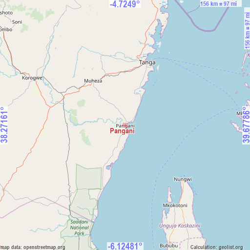
Pangani GPS coordinates[2]
5° 25' 30.936" South, 38° 58' 29.028" East
| Map corner | latitude | longitude |
|---|---|---|
| Upper-left | -4.7249°, | 38.27161° |
| Center: | -5.42526°, | 38.97473° |
| Lower-right: | -6.12481°, | 39.67786° |
| Map W x H: | 155.7×155.7 km | = 96.7×96.7mi |
| max Lat: | -1.14389° ⇑52.1% North |
| Pangani: | -5.42526° |
| min Lat: | ⇓47.9% South -11.36667° |
| min Long | Pangani | max Long |
| 29.62667° | 38.97473° | 40.33333° |
| W 83.6%⇐ | ⇒16.4% E |
Elevation
Elevation of Pangani is 9 m = 30 ft, and this is 933.8 m = 3064 ft below average elevation for this country.
| Max E: |
2377 m = 7799 ft | 98.6% |
| Avg. | 942.8 m = 3093 ft | |
| Pangani | 9 m = 30 ft | |
Min E: |
0 m = 0 ft | 1.4% |
See also: Tanzania elevation on elevation.city.
Geographical zone
Pangani is located in South Torrid zone (between Equator and Tropic of Capricorn). Distance of Equator is 603.2 km =374.8 mi to North.| Distance of | km | miles | from Pangani |
|---|---|---|---|
| Equator | 603.2 | 374.8 | to North |
| Tropic Capricorn | 2002.7 | 1244.4 | to South |
| Antarctic Circle | 6797.9 | 4224 | to South |
| South Pole | 9403.8 | 5843.2 | to South |


Nearby cities:
15 places around Pangani: (largest is in red/bold)
• Gamba
63.9 km =39.7 mi,  145°
145°
• Kijini
60.5 km =37.6 mi,  141°
141°
• Kiwengwa
76.9 km =47.8 mi, 144°
• Koani
85.8 km =53.3 mi,  156°
156°
• Koani Ndogo
85.8 km =53.3 mi, 156°
• Majengo
30.6 km =19 mi,  1°
1°
• Maramba
57.6 km =35.8 mi,  316°
316°
• Mkokotoni
58.9 km =36.6 mi, 148°
• Mlalo
54.9 km =34.1 mi,  355°
355°
• Mtambile
80.4 km =50 mi,  86°
86°
• Muheza
35.7 km =22.2 mi, 323°
• Nungwi
49.1 km =30.5 mi,  133°
133°
• Tanga
41.9 km =26 mi,  19°
19°
• Uwelini
78.5 km =48.8 mi, 87°
• Zanzibar
85.8 km =53.3 mi, 163°
Sources, notices
• [Note1] Compared only with cities in Tanzania existing in our database
• [Src1] Map data: © OpenStreetMap contributors (CC-BY-SA)
• [Src2] Other city data from geonames.org with taken over terms of usage.
• [Src3] Geographical zone / Annual Mean Temperature by Robert A. Rohde @ Wikipedia
