Zanzibar geodata
Zanzibar (Zanzibar Urban/West) is a seat of a first-order administrative division; located in Tanzania in Africa/Dar_es_Salaam (GMT+3) time zone. With population of 403,658 people, there are 2 cities with bigger population in this country. Compared to other cities in Tanzania, 57.3% of cities are located further ↑North; 87.1% of cities are located further ←West and 97.2% of cities have higher elevation than Zanzibar. Note1


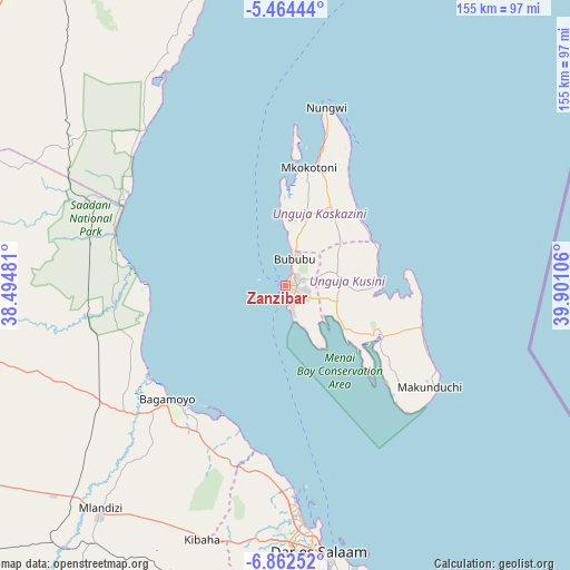
Zanzibar GPS coordinates[2]
6° 9' 50.184" South, 39° 11' 52.548" East
| Map corner | latitude | longitude |
|---|---|---|
| Upper-left | -5.46444°, | 38.49481° |
| Center: | -6.16394°, | 39.19793° |
| Lower-right: | -6.86252°, | 39.90106° |
| Map W x H: | 155.5×155.5 km | = 96.6×96.6mi |
| max Lat: | -1.14389° ⇑57.3% North |
| Zanzibar: | -6.16394° |
| min Lat: | ⇓42.7% South -11.36667° |
| min Long | Zanzibar | max Long |
| 29.62667° | 39.19793° | 40.33333° |
| W 87.1%⇐ | ⇒12.9% E |
Elevation
Elevation of Zanzibar is 14 m = 46 ft, and this is 928.8 m = 3047 ft below average elevation for this country.
| Max E: |
2377 m = 7799 ft | 97.2% |
| Avg. | 942.8 m = 3093 ft | |
| Zanzibar | 14 m = 46 ft | |
Min E: |
0 m = 0 ft | 2.8% |
See also: Zanzibar elevation on elevation.city.
Geographical zone
Zanzibar is located in South Torrid zone (between Equator and Tropic of Capricorn). Distance of Equator is 685.4 km =425.9 mi to North.| Distance of | km | miles | from Zanzibar |
|---|---|---|---|
| Equator | 685.4 | 425.9 | to North |
| Tropic Capricorn | 1920.6 | 1193.4 | to South |
| Antarctic Circle | 6715.8 | 4173 | to South |
| South Pole | 9321.7 | 5792.2 | to South |


Nearby cities:
15 places around Zanzibar: (largest is in red/bold)
• Bagamoyo
44.8 km =27.8 mi,  226°
226°
• Dar es Salaam
73.8 km =45.9 mi,  173°
173°
• Gamba
31.4 km =19.5 mi,  21°
21°
• Kibaha
73.9 km =45.9 mi,  204°
204°
• Kijini
37.3 km =23.2 mi, 20°
• Kiwengwa
27.7 km =17.2 mi,  45°
45°
• Koani
10 km =6.2 mi,  70°
70°
• Koani Ndogo
10 km =6.2 mi, 70°
• Magomeni
71 km =44.1 mi,  175°
175°
• Mahonda
43.5 km =27 mi,  136°
136°
• Mkokotoni
32.7 km =20.3 mi,  11°
11°
• Mvomero
59.5 km =37 mi,  260°
260°
• Nganane
46.9 km =29.1 mi,  124°
124°
• Nungwi
49.9 km =31 mi, 12°
• Sokoni
49.1 km =30.5 mi,  127°
127°
In other languages:
- In Spanish: Zanzíbar
- In German: Sansibar-Stadt
- In Russian: Занзибар
- In Chinese: 桑给巴尔市
Sources, notices
• [Note1] Compared only with cities in Tanzania existing in our database
• [Src1] Map data: © OpenStreetMap contributors (CC-BY-SA)
• [Src2] Other city data from geonames.org with taken over terms of usage.
• [Src3] Geographical zone / Annual Mean Temperature by Robert A. Rohde @ Wikipedia
