Tanga geodata
Tanga is a seat of a first-order administrative division; located in Tanzania in Africa/Dar_es_Salaam (GMT+3) time zone. With population of 224,876 people, there are 6 cities with bigger population in this country. Compared to other cities in Tanzania, 52.8% of cities are located further ↓South; 85.7% of cities are located further ←West and 95.5% of cities have higher elevation than Tanga. Note1


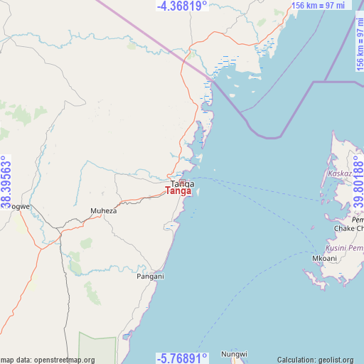
Tanga GPS coordinates[2]
5° 4' 8.148" South, 39° 5' 55.5" East
| Map corner | latitude | longitude |
|---|---|---|
| Upper-left | -4.36819°, | 38.39563° |
| Center: | -5.06893°, | 39.09875° |
| Lower-right: | -5.76891°, | 39.80188° |
| Map W x H: | 155.7×155.7 km | = 96.7×96.7mi |
| max Lat: | -1.14389° ⇑47.2% North |
| Tanga: | -5.06893° |
| min Lat: | ⇓52.8% South -11.36667° |
| min Long | Tanga | max Long |
| 29.62667° | 39.09875° | 40.33333° |
| W 85.7%⇐ | ⇒14.3% E |
Elevation
Elevation of Tanga is 22 m = 72 ft, and this is 920.8 m = 3021 ft below average elevation for this country.
| Max E: |
2377 m = 7799 ft | 95.5% |
| Avg. | 942.8 m = 3093 ft | |
| Tanga | 22 m = 72 ft | |
Min E: |
0 m = 0 ft | 4.5% |
See also: Tanga elevation on elevation.city.
Geographical zone
Tanga is located in South Torrid zone (between Equator and Tropic of Capricorn). Distance of Equator is 563.6 km =350.2 mi to North.| Distance of | km | miles | from Tanga |
|---|---|---|---|
| Equator | 563.6 | 350.2 | to North |
| Tropic Capricorn | 2042.3 | 1269 | to South |
| Antarctic Circle | 6837.6 | 4248.7 | to South |
| South Pole | 9443.4 | 5867.9 | to South |


Nearby cities:
15 places around Tanga: (largest is in red/bold)
• Chake Chake
76.5 km =47.5 mi,  104°
104°
• Kijini
90.1 km =56 mi,  164°
164°
• Konde
73.3 km =45.5 mi,  79°
79°
• Majengo
15.6 km =9.7 mi,  234°
234°
• Maramba
53.4 km =33.2 mi,  272°
272°
• Micheweni
82.2 km =51.1 mi, 82°
• Mkokotoni
91.3 km =56.7 mi,  169°
169°
• Mlalo
23.7 km =14.7 mi,  309°
309°
• Mtambile
75.2 km =46.7 mi,  117°
117°
• Muheza
36.6 km =22.7 mi,  252°
252°
• Nungwi
76.4 km =47.5 mi, 163°
• Pangani
41.9 km =26 mi,  199°
199°
• Soni
84.7 km =52.6 mi,  286°
286°
• Uwelini
74.5 km =46.3 mi, 119°
• Wete
69.9 km =43.4 mi,  88°
88°
Sources, notices
• [Note1] Compared only with cities in Tanzania existing in our database
• [Src1] Map data: © OpenStreetMap contributors (CC-BY-SA)
• [Src2] Other city data from geonames.org with taken over terms of usage.
• [Src3] Geographical zone / Annual Mean Temperature by Robert A. Rohde @ Wikipedia
