Nganane geodata
Nganane (Zanzibar Central/South) is a populated place; located in Tanzania in Africa/Dar_es_Salaam (GMT+3) time zone. With population of 1,929 people, there are 285 cities with bigger population in this country. Compared to other cities in Tanzania, 60.5% of cities are located further ↑North; 94.1% of cities are located further ←West and 92.7% of cities have higher elevation than Nganane. Note1


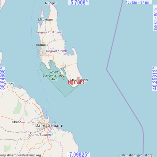
Nganane GPS coordinates[2]
6° 24' 0" South, 39° 33' 0" East
| Map corner | latitude | longitude |
|---|---|---|
| Upper-left | -5.7008°, | 38.84688° |
| Center: | -6.4°, | 39.55° |
| Lower-right: | -7.09825°, | 40.25313° |
| Map W x H: | 155.4×155.4 km | = 96.6×96.6mi |
| max Lat: | -1.14389° ⇑60.5% North |
| Nganane: | -6.4° |
| min Lat: | ⇓39.5% South -11.36667° |
| min Long | Nganane | max Long |
| 29.62667° | 39.55° | 40.33333° |
| W 94.1%⇐ | ⇒5.9% E |
Elevation
Elevation of Nganane is 31 m = 102 ft, and this is 911.8 m = 2991 ft below average elevation for this country.
| Max E: |
2377 m = 7799 ft | 92.7% |
| Avg. | 942.8 m = 3093 ft | |
| Nganane | 31 m = 102 ft | |
Min E: |
0 m = 0 ft | 7.3% |
See also: Tanzania elevation on elevation.city.
Geographical zone
Nganane is located in South Torrid zone (between Equator and Tropic of Capricorn). Distance of Equator is 711.6 km =442.2 mi to North.| Distance of | km | miles | from Nganane |
|---|---|---|---|
| Equator | 711.6 | 442.2 | to North |
| Tropic Capricorn | 1894.3 | 1177.1 | to South |
| Antarctic Circle | 6689.6 | 4156.7 | to South |
| South Pole | 9295.4 | 5775.9 | to South |


Nearby cities:
15 places around Nganane: (largest is in red/bold)
• Bagamoyo
71.5 km =44.4 mi,  266°
266°
• Dar es Salaam
56.4 km =35 mi,  213°
213°
• Gamba
62.1 km =38.6 mi,  333°
333°
• Kijini
66.4 km =41.3 mi,  337°
337°
• Kisarawe
77.1 km =47.9 mi,  223°
223°
• Kiwengwa
49.5 km =30.8 mi, 337°
• Koani
41.8 km =26 mi,  315°
315°
• Koani Ndogo
41.8 km =26 mi, 315°
• Magomeni
55.5 km =34.5 mi, 216°
• Mahonda
10.8 km =6.7 mi,  238°
238°
• Mkokotoni
66.8 km =41.5 mi, 330°
• Nungwi
79.9 km =49.6 mi, 339°
• Sokoni
3.7 km =2.3 mi,  180°
180°
• Vikindu
72.9 km =45.3 mi,  202°
202°
• Zanzibar
46.9 km =29.1 mi,  304°
304°
Sources, notices
• [Note1] Compared only with cities in Tanzania existing in our database
• [Src1] Map data: © OpenStreetMap contributors (CC-BY-SA)
• [Src2] Other city data from geonames.org with taken over terms of usage.
• [Src3] Geographical zone / Annual Mean Temperature by Robert A. Rohde @ Wikipedia
