Mahonda geodata
Mahonda (Zanzibar Central/South) is a populated place; located in Tanzania in Africa/Dar_es_Salaam (GMT+3) time zone. With population of 5,569 people, there are 269 cities with bigger population in this country. Compared to other cities in Tanzania, 61.9% of cities are located further ↑North; 93.7% of cities are located further ←West and 99.7% of cities have higher elevation than Mahonda. Note1
Administrative division(s):
- Level 1: Zanzibar Central/South
- Level 2: Kusini
- Level 3: Kizimkazi Mkunguni


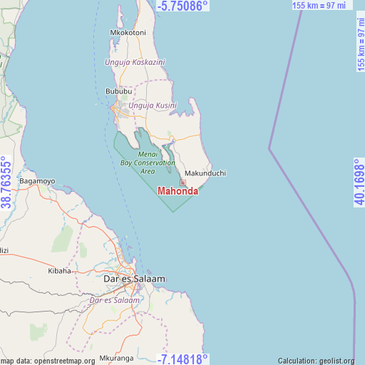
Mahonda GPS coordinates[2]
6° 27' 0" South, 39° 28' 0.012" East
| Map corner | latitude | longitude |
|---|---|---|
| Upper-left | -5.75086°, | 38.76355° |
| Center: | -6.45°, | 39.46667° |
| Lower-right: | -7.14818°, | 40.1698° |
| Map W x H: | 155.4×155.4 km | = 96.6×96.6mi |
| max Lat: | -1.14389° ⇑61.9% North |
| Mahonda: | -6.45° |
| min Lat: | ⇓38.1% South -11.36667° |
| min Long | Mahonda | max Long |
| 29.62667° | 39.46667° | 40.33333° |
| W 93.7%⇐ | ⇒6.3% E |
Elevation
Elevation of Mahonda is 5 m = 16 ft, and this is 937.8 m = 3077 ft below average elevation for this country.
| Max E: |
2377 m = 7799 ft | 99.7% |
| Avg. | 942.8 m = 3093 ft | |
| Mahonda | 5 m = 16 ft | |
Min E: |
0 m = 0 ft | 0.3% |
See also: Tanzania elevation on elevation.city.
Geographical zone
Mahonda is located in South Torrid zone (between Equator and Tropic of Capricorn). Distance of Equator is 717.2 km =445.6 mi to North.| Distance of | km | miles | from Mahonda |
|---|---|---|---|
| Equator | 717.2 | 445.6 | to North |
| Tropic Capricorn | 1888.7 | 1173.6 | to South |
| Antarctic Circle | 6684 | 4153.2 | to South |
| South Pole | 9289.9 | 5772.5 | to South |


Nearby cities:
15 places around Mahonda: (largest is in red/bold)
• Bagamoyo
62.1 km =38.6 mi,  270°
270°
• Dar es Salaam
46.9 km =29.1 mi,  207°
207°
• Gamba
63.9 km =39.7 mi,  343°
343°
• Kibaha
70.2 km =43.6 mi,  239°
239°
• Kijini
68.7 km =42.7 mi,  346°
346°
• Kisarawe
66.7 km =41.4 mi,  221°
221°
• Kiwengwa
52.1 km =32.4 mi, 349°
• Koani
40.6 km =25.2 mi,  330°
330°
• Koani Ndogo
40.6 km =25.2 mi, 330°
• Magomeni
45.7 km =28.4 mi, 211°
• Mkokotoni
68.1 km =42.3 mi, 339°
• Nganane
10.8 km =6.7 mi,  58°
58°
• Sokoni
9.4 km =5.8 mi,  78°
78°
• Vikindu
64.6 km =40.1 mi,  196°
196°
• Zanzibar
43.5 km =27 mi,  316°
316°
Sources, notices
• [Note1] Compared only with cities in Tanzania existing in our database
• [Src1] Map data: © OpenStreetMap contributors (CC-BY-SA)
• [Src2] Other city data from geonames.org with taken over terms of usage.
• [Src3] Geographical zone / Annual Mean Temperature by Robert A. Rohde @ Wikipedia
