Magomeni geodata
Magomeni (Dar es Salaam) is a section of populated place; located in Tanzania in Africa/Dar_es_Salaam (GMT+3) time zone. With population of 19,086 people, there are 136 cities with bigger population in this country. Compared to other cities in Tanzania, 65% of cities are located further ↑North; 88.1% of cities are located further ←West and 96.2% of cities have higher elevation than Magomeni. Note1


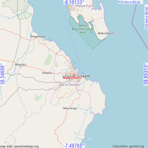
Magomeni GPS coordinates[2]
6° 48' 0" South, 39° 15' 0" East
| Map corner | latitude | longitude |
|---|---|---|
| Upper-left | -6.10133°, | 38.54688° |
| Center: | -6.8°, | 39.25° |
| Lower-right: | -7.49765°, | 39.95313° |
| Map W x H: | 155.3×155.3 km | = 96.5×96.5mi |
| max Lat: | -1.14389° ⇑65% North |
| Magomeni: | -6.8° |
| min Lat: | ⇓35% South -11.36667° |
| min Long | Magomeni | max Long |
| 29.62667° | 39.25° | 40.33333° |
| W 88.1%⇐ | ⇒11.9% E |
Elevation
Elevation of Magomeni is 21 m = 69 ft, and this is 921.8 m = 3024 ft below average elevation for this country.
| Max E: |
2377 m = 7799 ft | 96.2% |
| Avg. | 942.8 m = 3093 ft | |
| Magomeni | 21 m = 69 ft | |
Min E: |
0 m = 0 ft | 3.8% |
See also: Tanzania elevation on elevation.city.
Geographical zone
Magomeni is located in South Torrid zone (between Equator and Tropic of Capricorn). Distance of Equator is 756.1 km =469.8 mi to North.| Distance of | km | miles | from Magomeni |
|---|---|---|---|
| Equator | 756.1 | 469.8 | to North |
| Tropic Capricorn | 1849.8 | 1149.4 | to South |
| Antarctic Circle | 6645.1 | 4129.1 | to South |
| South Pole | 9251 | 5748.3 | to South |


Nearby cities:
15 places around Magomeni: (largest is in red/bold)
• Bagamoyo
55.1 km =34.2 mi,  316°
316°
• Dar es Salaam
3.4 km =2.1 mi,  140°
140°
• Kibaha
37 km =23 mi,  275°
275°
• Kisarawe
23.1 km =14.4 mi,  241°
241°
• Koani
74.2 km =46.1 mi,  2°
2°
• Koani Ndogo
74.2 km =46.1 mi, 2°
• Mahonda
45.7 km =28.4 mi,  31°
31°
• Maneromango
67.8 km =42.1 mi,  229°
229°
• Mkuranga
35.7 km =22.2 mi,  187°
187°
• Mlandizi
58.1 km =36.1 mi, 281°
• Mvomero
88.8 km =55.2 mi,  313°
313°
• Nganane
55.5 km =34.5 mi,  36°
36°
• Sokoni
52.5 km =32.6 mi, 39°
• Vikindu
23.6 km =14.7 mi,  166°
166°
• Zanzibar
71 km =44.1 mi,  355°
355°
Sources, notices
• [Note1] Compared only with cities in Tanzania existing in our database
• [Src1] Map data: © OpenStreetMap contributors (CC-BY-SA)
• [Src2] Other city data from geonames.org with taken over terms of usage.
• [Src3] Geographical zone / Annual Mean Temperature by Robert A. Rohde @ Wikipedia
