Kisarawe geodata
Kisarawe (Pwani) is a populated place; located in Tanzania in Africa/Dar_es_Salaam (GMT+3) time zone. With population of 12,507 people, there are 206 cities with bigger population in this country. Compared to other cities in Tanzania, 66.8% of cities are located further ↑North; 85.3% of cities are located further ←West and 83.6% of cities have higher elevation than Kisarawe. Note1


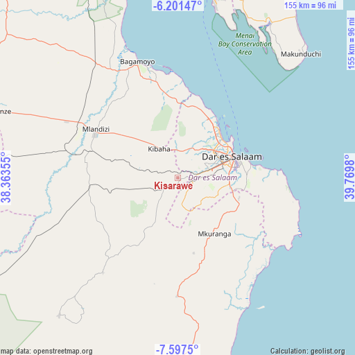
Kisarawe GPS coordinates[2]
6° 54' 0" South, 39° 4' 0.012" East
| Map corner | latitude | longitude |
|---|---|---|
| Upper-left | -6.20147°, | 38.36355° |
| Center: | -6.9°, | 39.06667° |
| Lower-right: | -7.5975°, | 39.7698° |
| Map W x H: | 155.2×155.2 km | = 96.4×96.4mi |
| max Lat: | -1.14389° ⇑66.8% North |
| Kisarawe: | -6.9° |
| min Lat: | ⇓33.2% South -11.36667° |
| min Long | Kisarawe | max Long |
| 29.62667° | 39.06667° | 40.33333° |
| W 85.3%⇐ | ⇒14.7% E |
Elevation
Elevation of Kisarawe is 221 m = 725 ft, and this is 721.8 m = 2368 ft below average elevation for this country.
| Max E: |
2377 m = 7799 ft | 83.6% |
| Avg. | 942.8 m = 3093 ft | |
| Kisarawe | 221 m = 725 ft | |
Min E: |
0 m = 0 ft | 16.4% |
See also: Tanzania elevation on elevation.city.
Geographical zone
Kisarawe is located in South Torrid zone (between Equator and Tropic of Capricorn). Distance of Equator is 767.2 km =476.7 mi to North.| Distance of | km | miles | from Kisarawe |
|---|---|---|---|
| Equator | 767.2 | 476.7 | to North |
| Tropic Capricorn | 1838.7 | 1142.5 | to South |
| Antarctic Circle | 6634 | 4122.2 | to South |
| South Pole | 9239.9 | 5741.4 | to South |


Nearby cities:
15 places around Kisarawe: (largest is in red/bold)
• Bagamoyo
54 km =33.6 mi,  340°
340°
• Bungu
81.6 km =50.7 mi,  180°
180°
• Chalinze
83.9 km =52.1 mi,  290°
290°
• Dar es Salaam
24 km =14.9 mi,  69°
69°
• Kibaha
22.2 km =13.8 mi,  311°
311°
• Magomeni
23.1 km =14.4 mi,  61°
61°
• Mahonda
66.7 km =41.4 mi,  41°
41°
• Maneromango
45.5 km =28.3 mi,  223°
223°
• Mkuranga
28.8 km =17.9 mi,  147°
147°
• Mlandizi
43 km =26.7 mi,  301°
301°
• Mvomero
84.7 km =52.6 mi,  328°
328°
• Nganane
77.1 km =47.9 mi, 43°
• Sokoni
74.4 km =46.2 mi,  45°
45°
• Vikindu
28.2 km =17.5 mi,  114°
114°
• Zanzibar
83.1 km =51.6 mi,  10°
10°
Sources, notices
• [Note1] Compared only with cities in Tanzania existing in our database
• [Src1] Map data: © OpenStreetMap contributors (CC-BY-SA)
• [Src2] Other city data from geonames.org with taken over terms of usage.
• [Src3] Geographical zone / Annual Mean Temperature by Robert A. Rohde @ Wikipedia
