Laela geodata
Laela (Rukwa) is a populated place; located in Tanzania in Africa/Dar_es_Salaam (GMT+3) time zone. With population of 19,185 people, there are 134 cities with bigger population in this country. Compared to other cities in Tanzania, 76.9% of cities are located further ↑North; 86.7% of cities are located further →East and 87.4% of cities have lower elevation than Laela. Note1


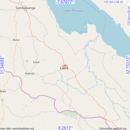
Laela GPS coordinates[2]
8° 34' 0.012" South, 32° 3' 0" East
| Map corner | latitude | longitude |
|---|---|---|
| Upper-left | -7.87077°, | 31.34688° |
| Center: | -8.56667°, | 32.05° |
| Lower-right: | -9.2613°, | 32.75313° |
| Map W x H: | 154.6×154.6 km | = 96.1×96.1mi |
| max Lat: | -1.14389° ⇑76.9% North |
| Laela: | -8.56667° |
| min Lat: | ⇓23.1% South -11.36667° |
| min Long | Laela | max Long |
| 29.62667° | 32.05° | 40.33333° |
| W 13.3%⇐ | ⇒86.7% E |
Elevation
Elevation of Laela is 1564 m = 5131 ft, and this is 621.2 m = 2038 ft above average elevation for this country.
| Max E: |
2377 m = 7799 ft | 12.6% |
| Laela | 1564 m 5131 ft | |
| Avg. | 942.8 m = 3093 ft | |
Min E: |
0 m = 0 ft | 87.4% |
See also: Tanzania elevation on elevation.city.
Geographical zone
Laela is located in South Torrid zone (between Equator and Tropic of Capricorn). Distance of Equator is 952.5 km =591.9 mi to North.| Distance of | km | miles | from Laela |
|---|---|---|---|
| Equator | 952.5 | 591.9 | to North |
| Tropic Capricorn | 1653.4 | 1027.4 | to South |
| Antarctic Circle | 6448.6 | 4007 | to South |
| South Pole | 9054.5 | 5626.2 | to South |


Nearby cities:
15 places around Laela: (largest is in red/bold)
• Chala
139.3 km =86.6 mi,  321°
321°
• Ilembo
165 km =102.5 mi,  117°
117°
• Itumba
155.2 km =96.4 mi,  126°
126°
• Katumba
187.4 km =116.4 mi,  113°
113°
• Kiwira
177.2 km =110.1 mi, 112°
• Matai
65.7 km =40.8 mi,  296°
296°
• Mbeya
158.3 km =98.4 mi,  103°
103°
• Mlowo
113.3 km =70.4 mi, 115°
• Namanyere
160.5 km =99.7 mi, 316°
• Nkove
148.8 km =92.5 mi, 297°
• Sumbawanga
82 km =51 mi, 324°
• Tunduma
113.3 km =70.4 mi,  136°
136°
• Ulenje
184.1 km =114.4 mi, 102°
• Usevia
186.2 km =115.7 mi,  331°
331°
• Vwawa
114.3 km =71 mi, 121°
Sources, notices
• [Note1] Compared only with cities in Tanzania existing in our database
• [Src1] Map data: © OpenStreetMap contributors (CC-BY-SA)
• [Src2] Other city data from geonames.org with taken over terms of usage.
• [Src3] Geographical zone / Annual Mean Temperature by Robert A. Rohde @ Wikipedia
