Mugumu geodata
Mugumu (Mara) is a populated place; located in Tanzania in Africa/Dar_es_Salaam (GMT+3) time zone. With population of 18,431 people, there are 147 cities with bigger population in this country. Compared to other cities in Tanzania, 94.8% of cities are located further ↓South; 57% of cities are located further →East and 87.1% of cities have lower elevation than Mugumu. Note1


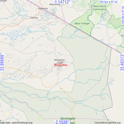
Mugumu GPS coordinates[2]
1° 51' 0" South, 34° 42' 0" East
| Map corner | latitude | longitude |
|---|---|---|
| Upper-left | -1.14712°, | 33.99688° |
| Center: | -1.85°, | 34.7° |
| Lower-right: | -2.5526°, | 35.40313° |
| Map W x H: | 156.3×156.3 km | = 97.1×97.1mi |
| max Lat: | -1.14389° ⇑5.2% North |
| Mugumu: | -1.85° |
| min Lat: | ⇓94.8% South -11.36667° |
| min Long | Mugumu | max Long |
| 29.62667° | 34.7° | 40.33333° |
| W 43%⇐ | ⇒57% E |
Elevation
Elevation of Mugumu is 1551 m = 5089 ft, and this is 608.2 m = 1995 ft above average elevation for this country.
| Max E: |
2377 m = 7799 ft | 12.9% |
| Mugumu | 1551 m 5089 ft | |
| Avg. | 942.8 m = 3093 ft | |
Min E: |
0 m = 0 ft | 87.1% |
See also: Tanzania elevation on elevation.city.
Geographical zone
Mugumu is located in South Torrid zone (between Equator and Tropic of Capricorn). Distance of Equator is 205.7 km =127.8 mi to North.| Distance of | km | miles | from Mugumu |
|---|---|---|---|
| Equator | 205.7 | 127.8 | to North |
| Tropic Capricorn | 2400.2 | 1491.4 | to South |
| Antarctic Circle | 7195.5 | 4471.1 | to South |
| South Pole | 9801.4 | 6090.3 | to South |


Nearby cities:
15 places around Mugumu: (largest is in red/bold)
• Bariadi
132.3 km =82.2 mi,  217°
217°
• Bunda
95.2 km =59.2 mi,  256°
256°
• Butiama
82 km =51 mi,  276°
276°
• Issenye
44 km =27.3 mi,  247°
247°
• Kibara
142.9 km =88.8 mi, 256°
• Kihangara
170.7 km =106.1 mi,  241°
241°
• Kisesa
150.1 km =93.3 mi,  204°
204°
• Maswa
122.2 km =75.9 mi, 220°
• Matonga
90.6 km =56.3 mi,  229°
229°
• Mugango
112.7 km =70 mi, 279°
• Musoma
107.3 km =66.7 mi,  291°
291°
• Nyakabindi
118 km =73.3 mi, 222°
• Nyamuswa
76.1 km =47.3 mi,  265°
265°
• Sirari
70.8 km =44 mi,  339°
339°
• Tarime
66.8 km =41.5 mi,  326°
326°
Sources, notices
• [Note1] Compared only with cities in Tanzania existing in our database
• [Src1] Map data: © OpenStreetMap contributors (CC-BY-SA)
• [Src2] Other city data from geonames.org with taken over terms of usage.
• [Src3] Geographical zone / Annual Mean Temperature by Robert A. Rohde @ Wikipedia
