Magole geodata
Magole (Morogoro) is a populated place; located in Tanzania in Africa/Dar_es_Salaam (GMT+3) time zone. With population of 18,753 people, there are 142 cities with bigger population in this country. Compared to other cities in Tanzania, 60.1% of cities are located further ↑North; 68.5% of cities are located further ←West and 75.2% of cities have higher elevation than Magole. Note1


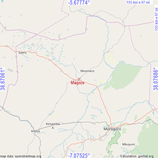
Magole GPS coordinates[2]
6° 22' 37.092" South, 37° 22' 25.428" East
| Map corner | latitude | longitude |
|---|---|---|
| Upper-left | -5.67774°, | 36.67061° |
| Center: | -6.37697°, | 37.37373° |
| Lower-right: | -7.07525°, | 38.07686° |
| Map W x H: | 155.4×155.4 km | = 96.6×96.6mi |
| max Lat: | -1.14389° ⇑60.1% North |
| Magole: | -6.37697° |
| min Lat: | ⇓39.9% South -11.36667° |
| min Long | Magole | max Long |
| 29.62667° | 37.37373° | 40.33333° |
| W 68.5%⇐ | ⇒31.5% E |
Elevation
Elevation of Magole is 433 m = 1421 ft, and this is 509.8 m = 1673 ft below average elevation for this country.
| Max E: |
2377 m = 7799 ft | 75.2% |
| Avg. | 942.8 m = 3093 ft | |
| Magole | 433 m = 1421 ft | |
Min E: |
0 m = 0 ft | 24.8% |
See also: Tanzania elevation on elevation.city.
Geographical zone
Magole is located in South Torrid zone (between Equator and Tropic of Capricorn). Distance of Equator is 709.1 km =440.6 mi to North.| Distance of | km | miles | from Magole |
|---|---|---|---|
| Equator | 709.1 | 440.6 | to North |
| Tropic Capricorn | 1896.9 | 1178.7 | to South |
| Antarctic Circle | 6692.1 | 4158.3 | to South |
| South Pole | 9298 | 5777.5 | to South |


Nearby cities:
15 places around Magole: (largest is in red/bold)
• Chalinze
112.1 km =69.7 mi,  104°
104°
• Chanika
128.3 km =79.7 mi,  33°
33°
• Geiro
61.5 km =38.2 mi,  294°
294°
• Kibakwe
117.5 km =73 mi,  251°
251°
• Kilosa
66.6 km =41.4 mi,  220°
220°
• Kimamba
52.4 km =32.6 mi,  210°
210°
• Kisanga
123.3 km =76.6 mi,  162°
162°
• Kongwa
107.6 km =66.9 mi,  280°
280°
• Lugoba
106.3 km =66.1 mi,  94°
94°
• Mikumi
122.1 km =75.9 mi,  200°
200°
• Morogoro
58.7 km =36.5 mi,  147°
147°
• Mpwapwa
98.4 km =61.1 mi,  271°
271°
• Msowero
25.9 km =16.1 mi,  227°
227°
• Mvomero
11.5 km =7.1 mi,  42°
42°
• Ngerengere
92 km =57.2 mi,  116°
116°
Sources, notices
• [Note1] Compared only with cities in Tanzania existing in our database
• [Src1] Map data: © OpenStreetMap contributors (CC-BY-SA)
• [Src2] Other city data from geonames.org with taken over terms of usage.
• [Src3] Geographical zone / Annual Mean Temperature by Robert A. Rohde @ Wikipedia
