Chalinze geodata
Chalinze (Pwani) is a populated place; located in Tanzania in Africa/Dar_es_Salaam (GMT+3) time zone. With population of 34,335 people, there are 49 cities with bigger population in this country. Compared to other cities in Tanzania, 62.6% of cities are located further ↑North; 76.9% of cities are located further ←West and 84.3% of cities have higher elevation than Chalinze. Note1


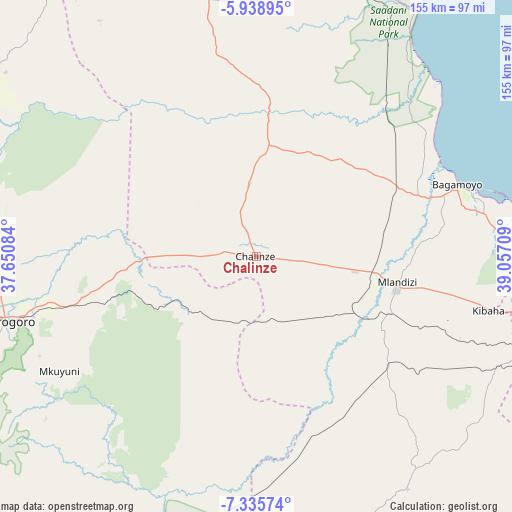
Chalinze GPS coordinates[2]
6° 38' 16.224" South, 38° 21' 14.256" East
| Map corner | latitude | longitude |
|---|---|---|
| Upper-left | -5.93895°, | 37.65084° |
| Center: | -6.63784°, | 38.35396° |
| Lower-right: | -7.33574°, | 39.05709° |
| Map W x H: | 155.3×155.3 km | = 96.5×96.5mi |
| max Lat: | -1.14389° ⇑62.6% North |
| Chalinze: | -6.63784° |
| min Lat: | ⇓37.4% South -11.36667° |
| min Long | Chalinze | max Long |
| 29.62667° | 38.35396° | 40.33333° |
| W 76.9%⇐ | ⇒23.1% E |
Elevation
Elevation of Chalinze is 212 m = 696 ft, and this is 730.8 m = 2398 ft below average elevation for this country.
| Max E: |
2377 m = 7799 ft | 84.3% |
| Avg. | 942.8 m = 3093 ft | |
| Chalinze | 212 m = 696 ft | |
Min E: |
0 m = 0 ft | 15.7% |
See also: Tanzania elevation on elevation.city.
Geographical zone
Chalinze is located in South Torrid zone (between Equator and Tropic of Capricorn). Distance of Equator is 738.1 km =458.6 mi to North.| Distance of | km | miles | from Chalinze |
|---|---|---|---|
| Equator | 738.1 | 458.6 | to North |
| Tropic Capricorn | 1867.9 | 1160.7 | to South |
| Antarctic Circle | 6663.1 | 4140.3 | to South |
| South Pole | 9269 | 5759.5 | to South |


Nearby cities:
15 places around Chalinze: (largest is in red/bold)
• Bagamoyo
64.6 km =40.1 mi,  70°
70°
• Dar es Salaam
103.2 km =64.1 mi,  101°
101°
• Kibaha
63.8 km =39.6 mi, 102°
• Kisarawe
83.9 km =52.1 mi,  110°
110°
• Lugoba
21 km =13 mi,  353°
353°
• Magomeni
100.6 km =62.5 mi, 100°
• Maneromango
78.4 km =48.7 mi,  142°
142°
• Mkuranga
108.3 km =67.3 mi,  119°
119°
• Mlandizi
42.5 km =26.4 mi, 99°
• Morogoro
79.2 km =49.2 mi,  255°
255°
• Mvomero
55.3 km =34.4 mi,  38°
38°
• Mvomero
107.3 km =66.7 mi,  290°
290°
• Ngerengere
29 km =18 mi,  244°
244°
• Vikindu
112.1 km =69.7 mi, 111°
• Zanzibar
107.1 km =66.5 mi,  60°
60°
Sources, notices
• [Note1] Compared only with cities in Tanzania existing in our database
• [Src1] Map data: © OpenStreetMap contributors (CC-BY-SA)
• [Src2] Other city data from geonames.org with taken over terms of usage.
• [Src3] Geographical zone / Annual Mean Temperature by Robert A. Rohde @ Wikipedia
