Kisanga geodata
Kisanga (Morogoro) is a populated place; located in Tanzania in Africa/Dar_es_Salaam (GMT+3) time zone. With population of 10,978 people, there are 227 cities with bigger population in this country. Compared to other cities in Tanzania, 69.9% of cities are located further ↑North; 70.3% of cities are located further ←West and 87.1% of cities have higher elevation than Kisanga. Note1


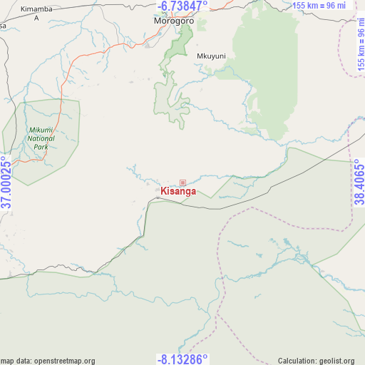
Kisanga GPS coordinates[2]
7° 26' 10.392" South, 37° 42' 12.132" East
| Map corner | latitude | longitude |
|---|---|---|
| Upper-left | -6.73847°, | 37.00025° |
| Center: | -7.43622°, | 37.70337° |
| Lower-right: | -8.13286°, | 38.4065° |
| Map W x H: | 155×155 km | = 96.3×96.3mi |
| max Lat: | -1.14389° ⇑69.9% North |
| Kisanga: | -7.43622° |
| min Lat: | ⇓30.1% South -11.36667° |
| min Long | Kisanga | max Long |
| 29.62667° | 37.70337° | 40.33333° |
| W 70.3%⇐ | ⇒29.7% E |
Elevation
Elevation of Kisanga is 150 m = 492 ft, and this is 792.8 m = 2601 ft below average elevation for this country.
| Max E: |
2377 m = 7799 ft | 87.1% |
| Avg. | 942.8 m = 3093 ft | |
| Kisanga | 150 m = 492 ft | |
Min E: |
0 m = 0 ft | 12.9% |
See also: Tanzania elevation on elevation.city.
Geographical zone
Kisanga is located in South Torrid zone (between Equator and Tropic of Capricorn). Distance of Equator is 826.8 km =513.7 mi to North.| Distance of | km | miles | from Kisanga |
|---|---|---|---|
| Equator | 826.8 | 513.7 | to North |
| Tropic Capricorn | 1779.1 | 1105.5 | to South |
| Antarctic Circle | 6574.3 | 4085.1 | to South |
| South Pole | 9180.2 | 5704.3 | to South |


Nearby cities:
15 places around Kisanga: (largest is in red/bold)
• Chalinze
114.2 km =71 mi,  38°
38°
• Ifakara
136.5 km =84.8 mi,  235°
235°
• Kidatu
87.3 km =54.2 mi,  250°
250°
• Kidodi
79.3 km =49.3 mi,  256°
256°
• Kilosa
103.9 km =64.6 mi,  310°
310°
• Kimamba
96.1 km =59.7 mi,  319°
319°
• Lugoba
129.8 km =80.7 mi,  32°
32°
• Magole
123.3 km =76.6 mi,  342°
342°
• Maneromango
122.1 km =75.9 mi,  77°
77°
• Mikumi
79.5 km =49.4 mi,  272°
272°
• Morogoro
68.6 km =42.6 mi,  356°
356°
• Msowero
114.7 km =71.3 mi,  331°
331°
• Mvomero
129.4 km =80.4 mi,  347°
347°
• Ngerengere
88.9 km =55.2 mi, 30°
• Utete
131.3 km =81.6 mi,  117°
117°
Sources, notices
• [Note1] Compared only with cities in Tanzania existing in our database
• [Src1] Map data: © OpenStreetMap contributors (CC-BY-SA)
• [Src2] Other city data from geonames.org with taken over terms of usage.
• [Src3] Geographical zone / Annual Mean Temperature by Robert A. Rohde @ Wikipedia
