Mpwapwa geodata
Mpwapwa (Dodoma) is a populated place; located in Tanzania in Africa/Dar_es_Salaam (GMT+3) time zone. With population of 19,806 people, there are 125 cities with bigger population in this country. Compared to other cities in Tanzania, 59.8% of cities are located further ↑North; 60.5% of cities are located further ←West and 57.7% of cities have higher elevation than Mpwapwa. Note1


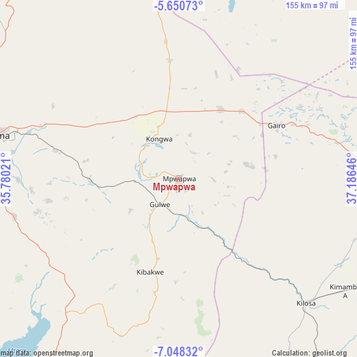
Mpwapwa GPS coordinates[2]
6° 21' 0" South, 36° 28' 59.988" East
| Map corner | latitude | longitude |
|---|---|---|
| Upper-left | -5.65073°, | 35.78021° |
| Center: | -6.35°, | 36.48333° |
| Lower-right: | -7.04832°, | 37.18646° |
| Map W x H: | 155.4×155.4 km | = 96.6×96.6mi |
| max Lat: | -1.14389° ⇑59.8% North |
| Mpwapwa: | -6.35° |
| min Lat: | ⇓40.2% South -11.36667° |
| min Long | Mpwapwa | max Long |
| 29.62667° | 36.48333° | 40.33333° |
| W 60.5%⇐ | ⇒39.5% E |
Elevation
Elevation of Mpwapwa is 998 m = 3274 ft, and this is 55.2 m = 181 ft above average elevation for this country.
| Max E: |
2377 m = 7799 ft | 57.7% |
| Mpwapwa | 998 m 3274 ft | |
| Avg. | 942.8 m = 3093 ft | |
Min E: |
0 m = 0 ft | 42.3% |
See also: Tanzania elevation on elevation.city.
Geographical zone
Mpwapwa is located in South Torrid zone (between Equator and Tropic of Capricorn). Distance of Equator is 706.1 km =438.8 mi to North.| Distance of | km | miles | from Mpwapwa |
|---|---|---|---|
| Equator | 706.1 | 438.8 | to North |
| Tropic Capricorn | 1899.9 | 1180.5 | to South |
| Antarctic Circle | 6695.1 | 4160.1 | to South |
| South Pole | 9301 | 5779.4 | to South |


Nearby cities:
15 places around Mpwapwa: (largest is in red/bold)
• Dodoma
84.6 km =52.6 mi,  283°
283°
• Geiro
47.9 km =29.8 mi,  62°
62°
• Izazi
125.7 km =78.1 mi,  221°
221°
• Kibakwe
42.8 km =26.6 mi,  197°
197°
• Kibaya
117.1 km =72.8 mi,  4°
4°
• Kilosa
77.1 km =47.9 mi,  134°
134°
• Kimamba
86.5 km =53.7 mi,  123°
123°
• Kisasa
78.8 km =49 mi, 284°
• Kongwa
18.2 km =11.3 mi,  336°
336°
• Magole
98.4 km =61.1 mi,  91°
91°
• Mikumi
129.5 km =80.5 mi,  154°
154°
• Morogoro
140.3 km =87.2 mi,  111°
111°
• Msanga
59.9 km =37.2 mi,  303°
303°
• Msowero
81.8 km =50.8 mi,  104°
104°
• Mvomero
106.3 km =66.1 mi, 87°
Sources, notices
• [Note1] Compared only with cities in Tanzania existing in our database
• [Src1] Map data: © OpenStreetMap contributors (CC-BY-SA)
• [Src2] Other city data from geonames.org with taken over terms of usage.
• [Src3] Geographical zone / Annual Mean Temperature by Robert A. Rohde @ Wikipedia
