Ngerengere geodata
Ngerengere (Morogoro) is a populated place; located in Tanzania in Africa/Dar_es_Salaam (GMT+3) time zone. With population of 17,181 people, there are 160 cities with bigger population in this country. Compared to other cities in Tanzania, 64% of cities are located further ↑North; 74.5% of cities are located further ←West and 84.6% of cities have higher elevation than Ngerengere. Note1


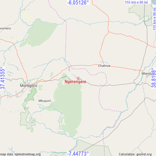
Ngerengere GPS coordinates[2]
6° 45' 0" South, 38° 7' 0.012" East
| Map corner | latitude | longitude |
|---|---|---|
| Upper-left | -6.05126°, | 37.41355° |
| Center: | -6.75°, | 38.11667° |
| Lower-right: | -7.44773°, | 38.8198° |
| Map W x H: | 155.3×155.3 km | = 96.5×96.5mi |
| max Lat: | -1.14389° ⇑64% North |
| Ngerengere: | -6.75° |
| min Lat: | ⇓36% South -11.36667° |
| min Long | Ngerengere | max Long |
| 29.62667° | 38.11667° | 40.33333° |
| W 74.5%⇐ | ⇒25.5% E |
Elevation
Elevation of Ngerengere is 196 m = 643 ft, and this is 746.8 m = 2450 ft below average elevation for this country.
| Max E: |
2377 m = 7799 ft | 84.6% |
| Avg. | 942.8 m = 3093 ft | |
| Ngerengere | 196 m = 643 ft | |
Min E: |
0 m = 0 ft | 15.4% |
See also: Tanzania elevation on elevation.city.
Geographical zone
Ngerengere is located in South Torrid zone (between Equator and Tropic of Capricorn). Distance of Equator is 750.5 km =466.3 mi to North.| Distance of | km | miles | from Ngerengere |
|---|---|---|---|
| Equator | 750.5 | 466.3 | to North |
| Tropic Capricorn | 1855.4 | 1152.9 | to South |
| Antarctic Circle | 6650.6 | 4132.5 | to South |
| South Pole | 9256.5 | 5751.7 | to South |


Nearby cities:
15 places around Ngerengere: (largest is in red/bold)
• Bagamoyo
93.5 km =58.1 mi,  68°
68°
• Chalinze
29 km =18 mi,  64°
64°
• Kibaha
88.4 km =54.9 mi,  91°
91°
• Kimamba
108.6 km =67.5 mi,  268°
268°
• Kisanga
88.9 km =55.2 mi,  210°
210°
• Kisarawe
106.2 km =66 mi,  99°
99°
• Lugoba
41.1 km =25.5 mi,  35°
35°
• Magole
92 km =57.2 mi,  296°
296°
• Magomeni
125.3 km =77.9 mi, 92°
• Maneromango
89 km =55.3 mi,  124°
124°
• Mlandizi
68.3 km =42.4 mi, 85°
• Morogoro
50.9 km =31.6 mi,  261°
261°
• Msowero
104.1 km =64.7 mi,  283°
283°
• Mvomero
82.4 km =51.2 mi,  47°
47°
• Mvomero
89.5 km =55.6 mi, 303°
Sources, notices
• [Note1] Compared only with cities in Tanzania existing in our database
• [Src1] Map data: © OpenStreetMap contributors (CC-BY-SA)
• [Src2] Other city data from geonames.org with taken over terms of usage.
• [Src3] Geographical zone / Annual Mean Temperature by Robert A. Rohde @ Wikipedia
