Maneromango geodata
Maneromango (Pwani) is a populated place; located in Tanzania in Africa/Dar_es_Salaam (GMT+3) time zone. With population of 9,402 people, there are 245 cities with bigger population in this country. Compared to other cities in Tanzania, 68.2% of cities are located further ↑North; 80.4% of cities are located further ←West and 76.6% of cities have higher elevation than Maneromango. Note1


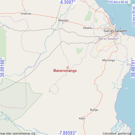
Maneromango GPS coordinates[2]
7° 11' 55.68" South, 38° 47' 5.208" East
| Map corner | latitude | longitude |
|---|---|---|
| Upper-left | -6.5007°, | 38.08166° |
| Center: | -7.1988°, | 38.78478° |
| Lower-right: | -7.89583°, | 39.48791° |
| Map W x H: | 155.1×155.1 km | = 96.4×96.4mi |
| max Lat: | -1.14389° ⇑68.2% North |
| Maneromango: | -7.1988° |
| min Lat: | ⇓31.8% South -11.36667° |
| min Long | Maneromango | max Long |
| 29.62667° | 38.78478° | 40.33333° |
| W 80.4%⇐ | ⇒19.6% E |
Elevation
Elevation of Maneromango is 383 m = 1257 ft, and this is 559.8 m = 1837 ft below average elevation for this country.
| Max E: |
2377 m = 7799 ft | 76.6% |
| Avg. | 942.8 m = 3093 ft | |
| Maneromango | 383 m = 1257 ft | |
Min E: |
0 m = 0 ft | 23.4% |
See also: Tanzania elevation on elevation.city.
Geographical zone
Maneromango is located in South Torrid zone (between Equator and Tropic of Capricorn). Distance of Equator is 800.4 km =497.3 mi to North.| Distance of | km | miles | from Maneromango |
|---|---|---|---|
| Equator | 800.4 | 497.3 | to North |
| Tropic Capricorn | 1805.5 | 1121.9 | to South |
| Antarctic Circle | 6600.7 | 4101.5 | to South |
| South Pole | 9206.6 | 5720.7 | to South |


Nearby cities:
15 places around Maneromango: (largest is in red/bold)
• Bagamoyo
85.2 km =52.9 mi,  8°
8°
• Bungu
57 km =35.4 mi,  148°
148°
• Chalinze
78.4 km =48.7 mi,  322°
322°
• Dar es Salaam
67.8 km =42.1 mi,  52°
52°
• Ikwiriri
86.7 km =53.9 mi,  166°
166°
• Kibaha
50.2 km =31.2 mi,  16°
16°
• Kibiti
60.5 km =37.6 mi,  163°
163°
• Kisarawe
45.5 km =28.3 mi,  43°
43°
• Magomeni
67.8 km =42.1 mi, 49°
• Mbumi
91.5 km =56.9 mi, 149°
• Mkuranga
47.5 km =29.5 mi,  79°
79°
• Mlandizi
55.8 km =34.7 mi,  354°
354°
• Ngerengere
89 km =55.3 mi,  304°
304°
• Utete
87.6 km =54.4 mi,  181°
181°
• Vikindu
60.6 km =37.7 mi,  69°
69°
Sources, notices
• [Note1] Compared only with cities in Tanzania existing in our database
• [Src1] Map data: © OpenStreetMap contributors (CC-BY-SA)
• [Src2] Other city data from geonames.org with taken over terms of usage.
• [Src3] Geographical zone / Annual Mean Temperature by Robert A. Rohde @ Wikipedia
