Bungu geodata
Bungu (Pwani) is a populated place; located in Tanzania in Africa/Dar_es_Salaam (GMT+3) time zone. With population of 27,873 people, there are 71 cities with bigger population in this country. Compared to other cities in Tanzania, 71.3% of cities are located further ↑North; 85% of cities are located further ←West and 86.4% of cities have higher elevation than Bungu. Note1


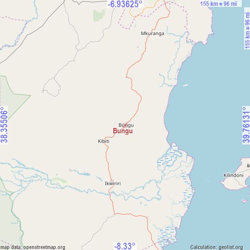
Bungu GPS coordinates[2]
7° 38' 1.284" South, 39° 3' 29.448" East
| Map corner | latitude | longitude |
|---|---|---|
| Upper-left | -6.93625°, | 38.35506° |
| Center: | -7.63369°, | 39.05818° |
| Lower-right: | -8.33°, | 39.76131° |
| Map W x H: | 155×155 km | = 96.3×96.3mi |
| max Lat: | -1.14389° ⇑71.3% North |
| Bungu: | -7.63369° |
| min Lat: | ⇓28.7% South -11.36667° |
| min Long | Bungu | max Long |
| 29.62667° | 39.05818° | 40.33333° |
| W 85%⇐ | ⇒15% E |
Elevation
Elevation of Bungu is 163 m = 535 ft, and this is 779.8 m = 2558 ft below average elevation for this country.
| Max E: |
2377 m = 7799 ft | 86.4% |
| Avg. | 942.8 m = 3093 ft | |
| Bungu | 163 m = 535 ft | |
Min E: |
0 m = 0 ft | 13.6% |
See also: Tanzania elevation on elevation.city.
Geographical zone
Bungu is located in South Torrid zone (between Equator and Tropic of Capricorn). Distance of Equator is 848.8 km =527.4 mi to North.| Distance of | km | miles | from Bungu |
|---|---|---|---|
| Equator | 848.8 | 527.4 | to North |
| Tropic Capricorn | 1757.1 | 1091.8 | to South |
| Antarctic Circle | 6552.4 | 4071.5 | to South |
| South Pole | 9158.3 | 5690.7 | to South |


Nearby cities:
15 places around Bungu: (largest is in red/bold)
• Bagamoyo
133.6 km =83 mi,  352°
352°
• Chalinze
135.3 km =84.1 mi,  324°
324°
• Dar es Salaam
93.1 km =57.8 mi,  14°
14°
• Ikwiriri
37.1 km =23.1 mi,  194°
194°
• Kibaha
97.7 km =60.7 mi, 350°
• Kibiti
16.5 km =10.3 mi,  233°
233°
• Kilindoni
73.5 km =45.7 mi,  115°
115°
• Kisarawe
81.6 km =50.7 mi,  0°
0°
• Magomeni
95.1 km =59.1 mi, 12°
• Maneromango
57 km =35.4 mi,  328°
328°
• Mbumi
34.6 km =21.5 mi,  150°
150°
• Mkuranga
59.7 km =37.1 mi,  16°
16°
• Mlandizi
109.8 km =68.2 mi,  340°
340°
• Utete
51.3 km =31.9 mi,  220°
220°
• Vikindu
74.6 km =46.4 mi, 20°
Sources, notices
• [Note1] Compared only with cities in Tanzania existing in our database
• [Src1] Map data: © OpenStreetMap contributors (CC-BY-SA)
• [Src2] Other city data from geonames.org with taken over terms of usage.
• [Src3] Geographical zone / Annual Mean Temperature by Robert A. Rohde @ Wikipedia
