Kibaha geodata
Kibaha (Pwani) is a seat of a first-order administrative division; located in Tanzania in Africa/Dar_es_Salaam (GMT+3) time zone. With population of 23,651 people, there are 97 cities with bigger population in this country. Compared to other cities in Tanzania, 64.3% of cities are located further ↑North; 81.8% of cities are located further ←West and 86.7% of cities have higher elevation than Kibaha. Note1


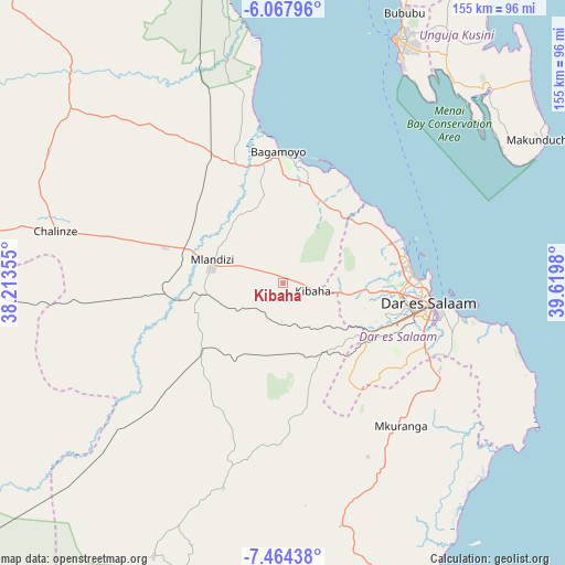
Kibaha GPS coordinates[2]
6° 46' 0.012" South, 38° 55' 0.012" East
| Map corner | latitude | longitude |
|---|---|---|
| Upper-left | -6.06796°, | 38.21355° |
| Center: | -6.76667°, | 38.91667° |
| Lower-right: | -7.46438°, | 39.6198° |
| Map W x H: | 155.3×155.3 km | = 96.5×96.5mi |
| max Lat: | -1.14389° ⇑64.3% North |
| Kibaha: | -6.76667° |
| min Lat: | ⇓35.7% South -11.36667° |
| min Long | Kibaha | max Long |
| 29.62667° | 38.91667° | 40.33333° |
| W 81.8%⇐ | ⇒18.2% E |
Elevation
Elevation of Kibaha is 154 m = 505 ft, and this is 788.8 m = 2588 ft below average elevation for this country.
| Max E: |
2377 m = 7799 ft | 86.7% |
| Avg. | 942.8 m = 3093 ft | |
| Kibaha | 154 m = 505 ft | |
Min E: |
0 m = 0 ft | 13.3% |
See also: Tanzania elevation on elevation.city.
Geographical zone
Kibaha is located in South Torrid zone (between Equator and Tropic of Capricorn). Distance of Equator is 752.4 km =467.5 mi to North.| Distance of | km | miles | from Kibaha |
|---|---|---|---|
| Equator | 752.4 | 467.5 | to North |
| Tropic Capricorn | 1853.5 | 1151.7 | to South |
| Antarctic Circle | 6648.8 | 4131.4 | to South |
| South Pole | 9254.7 | 5750.6 | to South |


Nearby cities:
15 places around Kibaha: (largest is in red/bold)
• Bagamoyo
36.1 km =22.4 mi,  357°
357°
• Chalinze
63.8 km =39.6 mi,  282°
282°
• Dar es Salaam
39.5 km =24.5 mi,  99°
99°
• Kisarawe
22.2 km =13.8 mi,  131°
131°
• Lugoba
73.4 km =45.6 mi,  298°
298°
• Magomeni
37 km =23 mi, 95°
• Mahonda
70.2 km =43.6 mi,  59°
59°
• Maneromango
50.2 km =31.2 mi,  196°
196°
• Mkuranga
50.6 km =31.4 mi,  140°
140°
• Mlandizi
21.6 km =13.4 mi,  290°
290°
• Mvomero
63.7 km =39.6 mi,  334°
334°
• Nganane
81 km =50.3 mi, 59°
• Sokoni
79.2 km =49.2 mi, 62°
• Vikindu
49.9 km =31 mi,  122°
122°
• Zanzibar
73.9 km =45.9 mi,  24°
24°
Sources, notices
• [Note1] Compared only with cities in Tanzania existing in our database
• [Src1] Map data: © OpenStreetMap contributors (CC-BY-SA)
• [Src2] Other city data from geonames.org with taken over terms of usage.
• [Src3] Geographical zone / Annual Mean Temperature by Robert A. Rohde @ Wikipedia
