Basotu geodata
Basotu (Manyara) is a populated place; located in Tanzania in Africa/Dar_es_Salaam (GMT+3) time zone. With population of 20,937 people, there are 117 cities with bigger population in this country. Compared to other cities in Tanzania, 64.3% of cities are located further ↓South; 50.7% of cities are located further →East and 90.6% of cities have lower elevation than Basotu. Note1


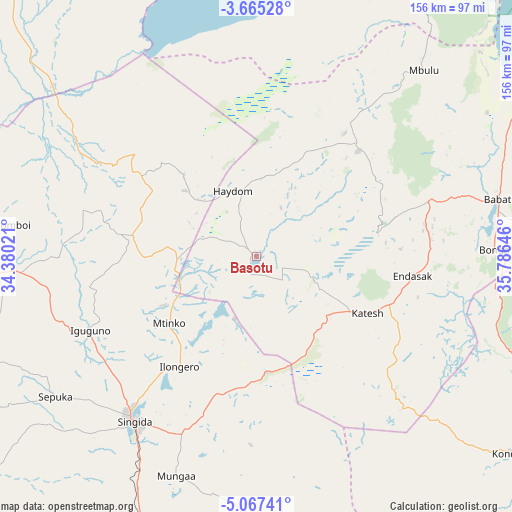
Basotu GPS coordinates[2]
4° 22' 0.012" South, 35° 4' 59.988" East
| Map corner | latitude | longitude |
|---|---|---|
| Upper-left | -3.66528°, | 34.38021° |
| Center: | -4.36667°, | 35.08333° |
| Lower-right: | -5.06741°, | 35.78646° |
| Map W x H: | 155.9×155.9 km | = 96.9×96.9mi |
| max Lat: | -1.14389° ⇑35.7% North |
| Basotu: | -4.36667° |
| min Lat: | ⇓64.3% South -11.36667° |
| min Long | Basotu | max Long |
| 29.62667° | 35.08333° | 40.33333° |
| W 49.3%⇐ | ⇒50.7% E |
Elevation
Elevation of Basotu is 1609 m = 5279 ft, and this is 666.2 m = 2186 ft above average elevation for this country.
| Max E: |
2377 m = 7799 ft | 9.4% |
| Basotu | 1609 m 5279 ft | |
| Avg. | 942.8 m = 3093 ft | |
Min E: |
0 m = 0 ft | 90.6% |
See also: Tanzania elevation on elevation.city.
Geographical zone
Basotu is located in South Torrid zone (between Equator and Tropic of Capricorn). Distance of Equator is 485.5 km =301.7 mi to North.| Distance of | km | miles | from Basotu |
|---|---|---|---|
| Equator | 485.5 | 301.7 | to North |
| Tropic Capricorn | 2120.4 | 1317.6 | to South |
| Antarctic Circle | 6915.6 | 4297.2 | to South |
| South Pole | 9521.5 | 5916.4 | to South |


Nearby cities:
15 places around Basotu: (largest is in red/bold)
• Babati
75.8 km =47.1 mi,  77°
77°
• Bashanet
39.8 km =24.7 mi,  68°
68°
• Dareda
54.4 km =33.8 mi, 72°
• Dongobesh
47.1 km =29.3 mi,  44°
44°
• Endasak
48.4 km =30.1 mi,  96°
96°
• Igugunu
54.6 km =33.9 mi,  245°
245°
• Ilongero
41.1 km =25.5 mi,  215°
215°
• Katesh
37.8 km =23.5 mi,  117°
117°
• Kiomboi
80.2 km =49.8 mi,  277°
277°
• Mbulu
76.1 km =47.3 mi, 40°
• Mtinko
32.9 km =20.4 mi,  231°
231°
• Mungaa
70.3 km =43.7 mi,  198°
198°
• Nangwa
42.1 km =26.2 mi,  105°
105°
• Sepuka
74.4 km =46.2 mi,  235°
235°
• Singida
62.6 km =38.9 mi, 216°
Sources, notices
• [Note1] Compared only with cities in Tanzania existing in our database
• [Src1] Map data: © OpenStreetMap contributors (CC-BY-SA)
• [Src2] Other city data from geonames.org with taken over terms of usage.
• [Src3] Geographical zone / Annual Mean Temperature by Robert A. Rohde @ Wikipedia
